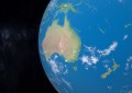
NASA has released an interactive map that provides a 3D view of Australia’s extreme smoke plumes from the ravaging bushfires that continue to devastate communities, providing a never-before-seen view to members of the public.
The map, which was created using Esri’s military-grade technology, shows imagery captured from a NASA Terra Satellite’s flight over the eastern coast of Australia on 16 December, 2019.
Using NASA’s new Multi-angle Imaging SpectroRadiometer (MISR) instrument to detect the height of smoke above the Earth’s surface by viewing it from various angles of space, the resulting satellite imagery provides what is said to be the first-ever interactive 3D visualisation of MISR fire plume-height data.
Painting a clear picture of the smoke plumes emanating from fires across the nation, this new map presents NASA’s data with the most accurate location detail, in a dynamic and interactive view. It is publicly available for anyone to use.
Leveraging the same technology being used by fire authorities on the frontline including NSW RFS, EMV VIC, SA CFS, and QFES, the map is aiding decision makers to unlock new smoke affect insights that will provide information to aid Australia’s long recovery from mass bushfire.
The Bureau of Meteorology (BOM) is already using the map to investigate improving air quality forecasts for the fires, whilst the NASA Disasters Program is studying short and long-term impacts and risks from the fires associated with air quality, aviation, wildlife and ecosystems, and climate dynamics.
The map can be accessed here: bit.ly/NASAsmokemap