

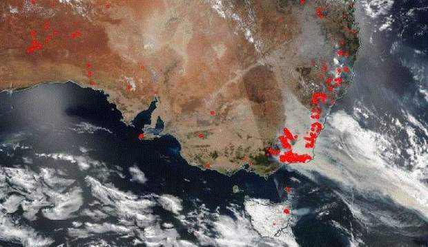
NASA thermal imaging of 2019/20 Australian bushfires.
Kate Crawford, Paul Reed and Roshni Sharma, Locate20 Organising Committee
Communication is vital to keep communities affected by bushfires proactive, resilient and prepared. The 2019/20 bushfire disasters have heightened public awareness of the need to improve communication within communities and with officials about danger and to locate resources in chaotic conditions when normal services are not available or visibility is low.
These disasters have highlighted the value of a much broader community capability to use and contribute to location data and communications in planning, managing risk, disaster management and recovery. A coordinated accessible system of map making, strategic sensor use, and social media communication and alerts would be one way to adapt to the new weather conditions.
If we can tap into the communities on-the-ground and help them to assist emergency services by providing spatial data to create a repository of local knowledge and information about what is where and in what condition, there are many positive implications for better emergency service results when there is heavy smoke, when power goes out, fuel is low and other such situations.
This will create a positive domino effect, assisting emergency services crews carrying out firefighting, repairs, and other assistance. People escaping fire-ravaged areas will be better able to understand where their most accessible evacuation centre is, where to obtain emergency food supplies, and the like – all traumatic activities which could be eased a little through using maps as a quick and easy communication tool.
The spatial industry has helped in the 2019-2020 fires, Digital Earth Australia has provided a significant resource for preparedness and response. Digital Earth Australia Hotspots (https://hotspots.dea.ga.gov.au/) displays bushfires around Australia as hotspots updated daily, pinpointing bushfires to an accuracy of 1.5km across the nation
Using satellite imagery such as this to feed into photogrammetry has allowed for faster and more accurate burn scar analysis, which is used to keep the public informed of the management of bushfires in apps such as the RFS “Fires Near Me’ and the SPARK application also (CSIRO, 2015). It uses geospatial data of vegetation, topography and unburnable elements such as infrastructure alongside weather data to model bushfire behaviour.
Social media has the power to connect people to each other, exchange up to date information, to share how a situation is evolving in real time, to hear about the national, or global impact of changes and to make informed decisions. . Agencies routinely monitor social media for crowdsourced information for disaster management. New thermal imaging and sensor data make it possible to extend our understanding in real time.
We have learned that spatial solutions to disaster management are about prevention, preparation and recovery as well as response. To be effective, spatial solutions need to be sustainable in the long-term, and used to expand on available tools, skills, services, R&D and technology and to engage everyone in the response and recovery. Spatial solutions, that use crowdsourced data, should work alongside existing command and control structures to enhance their effectiveness and value and respect the need for local informed decision making when limited rescue or service resources are not available
At Locate20 in Brisbane in April, we will be hearing from several speakers who will talk about new technology that is playing a role in better more integrated mapping systems. We will also hear from Mark Dunford who will be discussing information platforms and the impact they had during the 2019 bushfire season.
Engaging the community in recovery efforts and in better understanding ongoing risks, long-term impacts and how they can be proactively involved in recovery is important. Crowdsourcing data, including visualizations of spatial data, via Community Science platforms, offers a huge resource for both communities and utility management.
To hear more about the above issues, much more, visit www.locateconference.com/2020. Early bird registration is still available, but only for a limited time.


