
With a 10-year strategy well underway, Victoria is on track to deliver a land administration and cadastral system for the 21st century.
By Jonathan Nally
What should Victoria’s cadastral system look like in ten years’ time? To answer this question, Land Use Victoria (LUV) launched a 10-year strategy for advancing Victoria’s cadastral system in March 2024.
Co-developed with key stakeholders, the strategy outlines a vision and approach for delivering a future-ready land administration system to meet the needs of Government, industry and the wider community for generations to come.
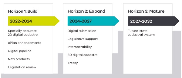
The strategy is being delivered over three horizons, each involving a number of steps. Over the last 12 months, LUV has worked with its stakeholders to deliver Horizon 1, including the completion of:
- The digital cadastre modernisation project, which upgraded the spatial accuracy of Victoria’s digital cadastre and the systems for its ongoing maintenance;
- Enhancements of the ePlan system, which is gearing up to provide the requisite functionality for the representation, submission, validation and download of digital cadastral plan and survey data;
- Development of a digital pipeline, including the delivery of a sophisticated digital examination tool, processing of cadastral plan and survey data, and the first phase of eComply; and
- Development of new products, including Vicmap Survey, Vicmap Buildings and Vicmap Utilities.
Horizon 2 will run from 2024 to 2027 and aims to:
- Take the next steps in the phased transition from PDF to ePlan for cadastral plan and survey data;
- Develop capability to handle 3D plans (e.g. building subdivisions, consolidations, tunnels, corridors and vistas) through the 3D Cadastral Survey Data Model (3D CDSM);
- Achieve data interoperability between cadastral and geospatial datasets; and
- Support Treaty negotiations.
Horizon 3 is due to run from 2027 to 2032 and will focus on maturing Victoria’s cadastral system and its digital capabilities. The goals and aspirations for the end of this period include:
- A fully digital, highly automated, spatially accurate 3D cadastral system;
- A system capable of handling 3D cadastral data;
- Mandatory digital submission and lodgement for all plan and survey information;
- Vicmap Survey being the product of choice for obtaining authoritative digital data relating to cadastral boundaries; and
- Seamless, end-to-end exchange and processing of cadastral information.
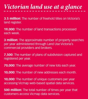
Victoria’s cadastre plays an important role in underpinning the state’s financial prosperity. The cadastre supports approximately one million land transactions annually, representing $700 million in land dealings in Victoria each day.
The 10-year strategy is being led by LUV, which is part of the Department of Transport and Planning, the state’s key agency for land registration and property information, surveying, land valuation, geographic names, government land policy and advice, and government land transaction oversight.
To find out a more about the program, we put the following questions to LUV.
What is the main impetus for the initiative?
The context for the strategy is population growth, technological advancement and increased community expectations for the services we deliver. Victoria’s population is forecast to exceed 10 million residents by 2051. The Victorian Government is driving reforms to tackle housing supply and affordability, with the state experiencing significant growth in property development, land subdivision, transport infrastructure, construction and high-density urban renewal.
At the same time, rapid and widespread adoption of digital technology is being seen in almost every sphere of life.
What are the principles and priorities of the program?
The key principles and priority areas for delivering our future state cadastral system include: a digital-by-default approach; a community focus; ongoing investment in data and infrastructure assets; co-design solutions with stakeholders; continuous improvement; development of capability, capacity and culture; and timely review of legislation, regulations and policy.
Victoria’s cadastral system is built on an invaluable repository of information spanning Victoria’s subdivision and land development history. This includes surveyed parcel boundaries, cadastral surveying measurements, evidence of fencing (or ‘occupation’), and related information about Crown and freehold parcels. It’s important we preserve this legacy for generations to come.
Tell us more about the delivery of Horizon 1
As outlined above, the first Horizon has focused on establishing the building blocks required for future transformation. The Digital Cadastre Modernisation (DCM) project included:
- Digitisation of cadastral information from more than a million PDF documents;
- Spatial and topological upgrade of Vicmap Property via least squares adjustment;
- Cascading these changes to other Vicmap themes; and
- Development of a digital pipeline for verifying, processing and adjusting new cadastral data to automate updates to Vicmap.
The DCM project embraced a ‘big data’ mindset that was open to exploring novel approaches to tackling computationally demanding tasks and complex problems efficiently, using open-source software supported by bespoke solutions and systems.
We have also taken opportunities to deliver additional value from the project, with the raw digitised data from the DCM project now available to surveyors via SPEAR as a new product called Vicmap Survey.
Another major output from Horizon 1 was the development of technology and infrastructure to support the digital examination and validation of subdivisions, providing increased integrity, more consistent decision making, process improvements and faster registration times.
What will be involved in the next two horizons?
With the fundamental building blocks in place, Horizon 2 will focus on further developing the systems to support the submission of digital cadastral data. As with any digital transformation journey, ongoing stakeholder engagement will be imperative to ensure a smooth transition.
LUV is taking an agile approach to ensure we can respond and adapt to changing stakeholder needs, feedback, highly variable ways of working across industry, and process efficiencies. This will also involve developing and implementing data standards to cater for all plan and survey based dealing types, and the harmonisation of digital data submission.
As innovative and more efficient ways for managing our cadastral system develop, we will take stock, reset and reprioritise outcomes where we need to.
Has there been much stakeholder involvement?
LUV worked closely with more than 200 stakeholders representing state and local government, industry, academia and professional institutions who interact with Victoria’s cadastral system. The strategy harnesses their views about what a future-ready cadastral system must deliver to government, industry and community sectors.
At the time of launching the strategy, LUV established a Surveyors Advisory Group to continue to incorporate stakeholder feedback across the phased delivery. The purpose of the Group is to provide peer-support, and to facilitate co-design of cadastral systems, products and services that maximise benefits for industry, government and the community.
Industry participation in the Group is helping to shape initiatives critical to the success of the strategy. This includes the ongoing development of ePlan (2D and 3D), digital cadastral standards for plans and surveys (2D and 3D), access to digital cadastral data for efficient reuse and performing pre-lodgement checks on plans, and matters relating to the copyright of cadastral data.
Who will benefit from the strategy?
The strategy provides benefits for all who rely on Victoria’s cadastral system including, industry professionals involved in subdivision and land development, federal, state and local governments (including government authorities, services authorities and emergency management), property owners and investors, academia and the general public.
The long-term benefits expected include: reduced costs to the state, industry and the community through reduced duplication of effort and manual processes; higher levels of integrity in the cadastre; more efficient ways for checking, verifying and publishing information; ready access to cadastral information that can be seamlessly integrated with other datasets; and maximising the re-use of digital data.
Have there been any surprises?
Yes, especially with the DCM project. Like most digital transformation projects, many previously hidden issues were uncovered. A program is now in place to progressively address these issues, for example, digitisation queries, anomalies in the cadastre, unadjusted blocks and zones, and areas showing poor levels of spatial quality.
The enormous scale and volume of data inevitably meant we found more food than we could digest. An inestimable amount of knowledge, skill and insight has been gained by all project participants and partners. In this context, the greatest challenge is how to harness and capitalise on the immense knowledge and experience gained from the project for the benefit of the organisation, industry and future generations.