


A version of Australia’s AquaWatch system will be established in the UK following the confirmation of bilateral support and co-funding from the two countries’ space agencies.
AquaWatch Australia, a national system for monitoring water quality and providing early warning forecasts of problems, was launched in 2023 by the CSIRO and foundational partner SmartSat CRC.
Since launching, AquaWatch has established multiple test sites to monitor bays, coastal wetlands, rivers, dams, lakes, aquaculture farming and coral reefs, including the Southern Great Barrier Reef.
AquaWatch Australia Mission Lead, Dr Alex Held, said AquaWatch integrates data from both a network of water-based sensors and satellite sensors.
“It’s a system we’re developing for Australia, but that can be adapted for other countries in need of national near-real time updates and forecasts,” Dr Held said.
“The importance of high-quality satellite data for AquaWatch means that global collaborations such as this help to enhance the system for everyone.”
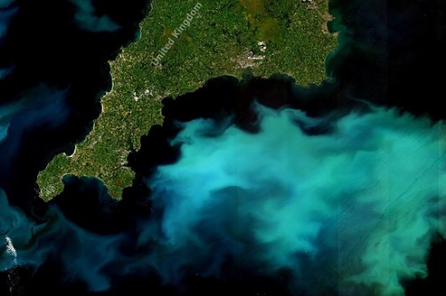
The formation of AquaWatch UK marks the first time the initiative will be rolled out by another country on a national scale, by expanding on a test site at Plymouth Sound.
AquaWatch was announced as a supported project under the UK Space Agency’s International Bilateral Fund, with co-funding from the Australian Space Agency, as part of the longstanding UK-Australia Space Bridge initiative.
Under the Space Bridge, partners will receive funding to advance the AquaWatch system in Australia and establish AquaWatch in the UK.
“By working with our international partners like the UK, we can continue to grow the Australian space sector while delivering outcomes that benefit communities in both of our nations,” said the Head of the Australian Space Agency, Enrico Palermo.
“Projects like AquaWatch reiterate how space technology, like Earth observation, can help address the biggest global challenges we are facing, as well as the power of working together to solve a common problem.”
According to SmartSat Cooperative Research Centre’s CEO, Professor Andy Koronios, SmartSat established strong ties with the UK space industry with the first UK Space Bridge initiative, funding five joint research initiatives in 2021.
“The AquaWatch UK project further underscores SmartSat’s commitment to delivering next-generation technologies and innovative projects that will accelerate the space sector in both Australia and the UK,” Prof Koronios said.
The lead partner for delivering AquaWatch in the UK will be Surrey Satellite Technology Ltd (SSTL). The company’s Head of Australia business, Clive Oates, said that “Working with CSIRO and SmartSat CRC on a comprehensive spacecraft platform study will also help accelerate Australia’s capability in the design, manufacture and test of Earth observation capabilities across both academia and industry”.
The collaboration will expand on test sites already established across Australia and with Plymouth Marine Laboratory (PML) in the UK, where AquaWatch is being tested to monitor water quality from the Tamar Bridge in Plymouth, Southwest England.
Dr Gavin Tilstone, Merit Scientist at PML and Principal Investigator of EO4Agriclimate Vis4Sea, said that as the planet heats up from global warming, we see increased flooding events.
“Using the AquaWatch infrastructure for Plymouth Sound, Vis4Sea is building a system to monitor the impacts of flooding on water quality, mud flats and sea grass beds, which play an important role in capturing CO2 from the atmosphere.”
Another EO4Agriclimate project, Living Coasts, is advancing the use of satellite observations to map land and water environments and their dynamics. Living Coasts researcher, Professor Richard Lucas of Aberystwyth University, said this enables AquaWatch users to gain a more complete picture and understanding of changes driving water quality.
“Working with Australian and UK partners, we are implementing our approach through data cubes of satellite data for both countries, but also in other regions including Southeast Asia, with this contributing to efforts focused on improving environments for people and nature,” said Prof Lucas.
In addition to CSIRO, SmartSat CRC and SSTL, AquaWatch AUK is supported by Assimila, RAL Space, Pixalytics and the Centre for Environment, Fisheries and Aquaculture Science (CEFAS).


