

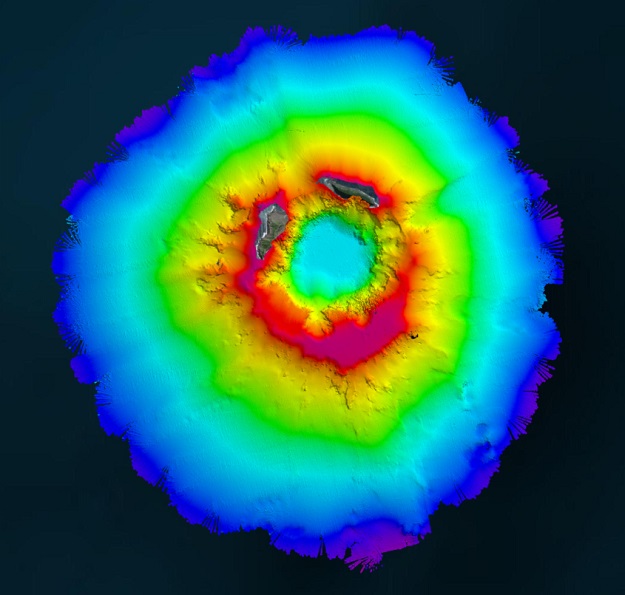
Aerial view of HT-HH, showing new multibeam depth data overlaid on a satellite image.
In April 2022, New Zealand’s National Institute of Water and Atmospheric Research (NIWA) and The Nippon Foundation announced a mission to discover the undersea impacts of the Hunga-Tonga Hunga-Ha’apai (HT–HH) volcanic eruption, which produced the biggest atmospheric explosion recorded on Earth in more than a century.
Supported by The Nippon Foundation-GEBCO Seabed 2030 Project, the Tonga Eruption Seabed Mapping Project (TESMaP) had two phases, led by NIWA. Phase one saw scientists survey the area around the volcano using the RV Tangaroa.
As part of phase two, SEA-KIT International’s uncrewed surface vessel (USV) Maxlimer was used to conduct further mapping inside the caldera.
For the duration of TESMaP, Seabed 2030 and Nippon Foundation-GEBCO Ocean Mapping Fellows used software provided by Teledyne CARIS.
The software was integral to the project as it facilitated the monitoring of data quality and coverage, with new data being used for comparative studies against previous maps to assess the effects of the eruption on marine life and seafloor composition.
Teledyne CARIS software will also be used to process the data to generate the final products.
The company’s “contribution to TESMaP has been invaluable,” said Seabed 2030 Project Director, Jamie McMichael-Phillips.
Stay up to date by getting stories like this delivered to your inbox.
Sign up to receive our free weekly Spatial Source newsletter.


