


NavVis and partners — Spatial Source, Lidar News, Lidar Magazine, the American Surveyor, GoGeomatics, GIM International, Geo Week, BIMplus and GeoConnexion — commissioned Statista to conduct a global study of surveying and scanning professionals in the laser scanning, surveying and AEC industries.
The goal of the State of Mobile Mapping Report 2022 was to map trends and emerging needs in the industry and track the usage and impression of new technologies.
With the laser scanning and surveying industry currently undergoing a major shift, the monitoring of industry trends has become all the more important to understand how emerging technologies can be best used by customers and which new initiatives will reshape the industry.
The survey prompted feedback from more than 200 industry professionals, and many insights were uncovered, such as:
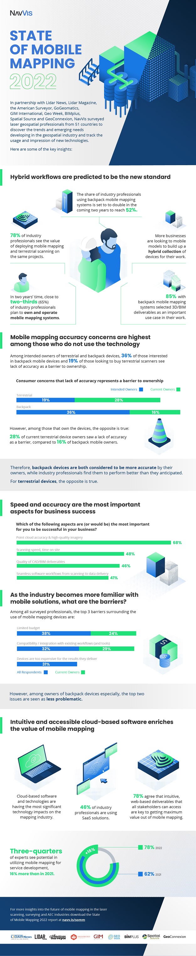
Mobile mapping continues to fulfill its potential. While less than two-thirds (62%) of survey participants in 2021 believed that mobile mapping technologies offer the potential to provide their end-clients with new services, this confidence grew to close to four-fifths (78%) of in the 2022 survey.
Point cloud accuracy remains the most important aspect for business success. When asked to cite the most important features in a scanner that would aid business success, a 68% majority of respondents revealed that point cloud accuracy and high-quality imagery were among their top three priorities. Close to half (48%) ranked scanning speed and the time on site among the same priorities.
The full report can be downloaded from http://navv.is/somm.
“We have seen that mobile mapping is driving significant positive change in a variety of industries — from surveying to laser scanning to AEC and more, and the results in the report are confirmation of that…,” said NavVis CEO and Co-founder, Dr. Felix Reinshagen.
“We hope that this report will give… an insight into the exciting world of mobile mapping and what changes and innovations are coming next.”
Stay up to date by getting stories like this delivered to your inbox.
Sign up to receive our free weekly Spatial Source newsletter.


