

The Leica Pegasus TRK Neo is a complete, high-level mobile mapping solution that’s far easier to use.
PARTNER FEATURE
Mobile mapping looks set to be transformed with the arrival of a highly capable new instrument, the Leica Pegasus TRK Neo from Leica Geosystems.
Leica describes the Pegasus TRK Neo as the ‘future of mobile mapping,’ and it’s easy to see why, as the instrument is easier to use than its predecessors and far more capable. The company hails its ability to make mobile mapping workflows autonomous and accessible to more professionals, thereby opening up more revenue and driving business opportunities across a wide range of industries.
Importantly, the TRK Neo can be used to accelerate users’ plans to create accurate, high-quality digital twins while also increasing efficiency in the field and in the office. And being easier to operate, the Pegasus TRK requires less training.
“It’s a very exciting piece of equipment,” said Sam Hesper, Scanning Sales Consultant at C.R. Kennedy, distributor of the Pegasus TRK Neo. “It’s designed to be a lot simpler, more autonomous and straightforward than previous versions of mobile mapping systems.”
The scanning hardware
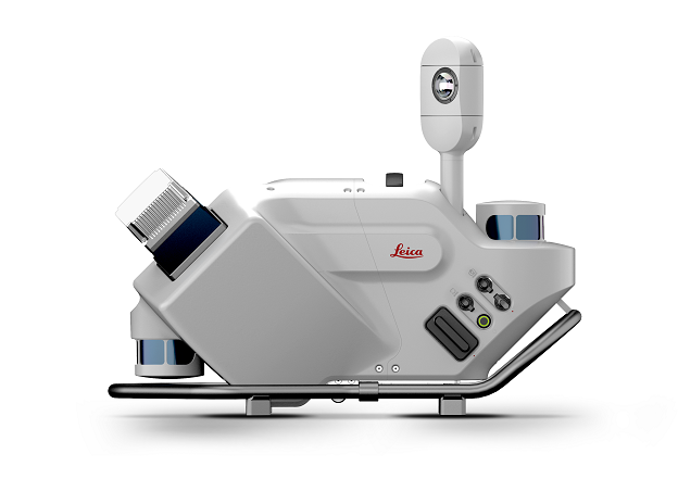
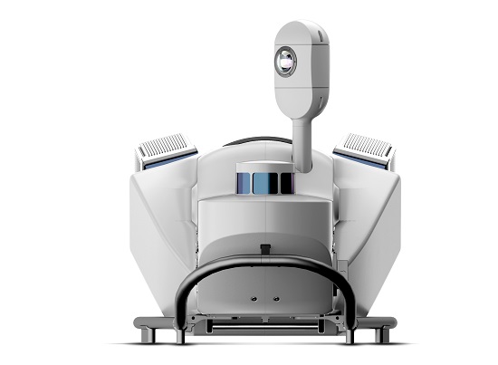
The Pegasus TRK Neo comes in two versions — the TRK500 Neo and the TRK700 Neo. The TRK500 Neo is a data-efficient single LiDAR scanner option, capturing 500,000 points per second. The TRK700 Neo has dual scanners for when higher point cloud density is required, capable of capturing one million points per second.
A typical installation will comprise either scanning unit, plus a control unit and a battery unit. The control unit enables the user to go straight from data capture to processing on-the-fly — no more time-consuming transcoding, storage overhead or errors during data transfer.
The battery unit has a safe transport mode, meaning the Li-Ion batteries can be transported safely. It is expandable with up to three batteries for up to 21 hours of operation or for hot-swapping for continuous power.
Weighing in at just 18 kg with its unique rotating-tilt mounting platform, the Pegasus TRK can be safely set up and operated by one person.
The ergonomic, lightweight carrier platform rotates and tilts to safely position the Pegasus TRK system on the user’s vehicle. The platform rotates into three positions (-30°/0°/+30°), which enables data collection from the TRK500 on the diagonal as well as a cross point cloud pattern from multi-pass acquisitions, usually achievable only with a dual scanner.
“The laser scanners provide full three-dimensional point cloud data sets of the environment. So if you’re going down a road and measuring, the road surface, the white lines, the road barriers, the signage, overhead power lines, bridges, trees and anything that you go past, will be mapped. All that information is really useful for engineering projects,” said Hesper.
There’s even an automated process where it can classify the data set into categories, such as pavement, vegetation, powerlines and so on.
The photogrammetry hardware
The Pegasus TRK features a 360⁰ panorama camera up top with add-on front, side and rear ‘butterfly’ cameras. Boosted with the additional detail cameras it brings the combined resolution of the system up a 120 MP. The additional cameras create data-rich imagery, while enhanced calibration delivers true-colour imagery according to the CIEDE2000 colour difference formula.
The integration of IMU and SLAM technology in Pegasus TRK’s sensor architecture enables georeferencing in challenging GNSS-denied environments. Precision RTK positioning gives location accuracy down to the centimetre, in real-time.
“You might be going through a tunnel, or you might be in an urban canyon. With the aid of the SLAM technology, it will hold the accuracy longer through those difficult areas, increasing the accuracy of the data,” said Hesper.
“The product has two circular scan heads. There’s one on the rear and one at bottom-front of the unit. They are separate laser scanner units that are collecting data for the SLAM, and all this is happening ‘behind the scenes’.”
Trajectory accuracy is further improved with the aid of both optical and mechanical Distance Measuring Units (DMIs) installed on the rear and side of the vehicle respectively. The DMIs accurately measure travel distance in GNSS-challenged conditions. The optical DMI provides further certainty through avoiding traditional slip error of wheel based DMIs.
The fully integrated modular imaging system enables the user to add more cameras for more angles, more detail and more possibilities, while automatic camera calibration simplifies and streamlines the system. Collection occurs at up to eight frames per second so that no details are missed.
The software
The all-new Leica Pegasus FIELD software brings autonomy to data collection, enabling users to plan routes and set goals for each project from the office or in the field. Reliable data acquisition considers satellite availability and signal coverage for automated routing, while edge computing and on-the-fly processing means data is collected and enhanced in real-time — at the speed of the traffic. The software guides the user through project set-up and planning, with an added ability to use predefined profiles to achieve the best possible results.
With an experience that will be familiar to users of the established Cyclone software ecosystem, Leica Cyclone Pegasus OFFICE provides a seamless data flow into post-processing and publishing workflows. Users can complete all their processing requirements in the one solution, including refining data with precision geo-referencing and multi-pass trajectory adjustment, and creating colourised 3D point cloud data that is automatically privacy compliant.
While in use, Intelligent routing is used to achieve the most efficient data collection, while sensors are triggered autonomously along the planned route. Live in-field viewing of data acquisition is highlighted on the base map.
People and vehicles are anonymised in real-time, protecting citizen privacy and ensuring GDPR compliance. Integrated with a real-time AI algorithm, the Pegasus TRK solution actively identifies and blurs entire objects directly in the imagery as the data is collected. All information is encrypted and doesn’t leave the Pegasus TRK system.
Putting it to use
“More productivity, easier to use, more ergonomic,” is how Hesper sums up the TRK Neo.
“You don’t have to be a full-blown expert in mobile mapping to be able to use it, and you can have a single person operating the equipment, where historically you’d need one person to drive the car and you’d have one person operating a laptop or computer in the passenger seat. But with the TRK it’s all done on a tablet screen, and it can all be pre-programmed,” he added.
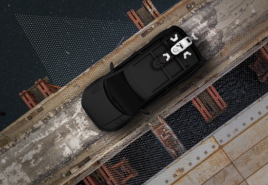
Hesper points out that it doesn’t have to be a passenger car — it can be mounted on any sort of moving platform.
“You can capture kilometres and kilometres of information in one day, and if you compare that to having a surveyor out there with a GPS pole or a total station, and how long it would take them to capture the amount of data this unit can, it just doesn’t compare,” said Hesper.
“And then you have the question of accessing the roadway. If it’s a freeway and there’s a big intersection to be done — how do you get surveyors on the road safely without closing lanes and creating all sorts of hassles? It’s very time-consuming and difficult to do that.
“But if you can just drive at road speed and do a few passes with this mobile scanner, you’ve got more data than you could have captured otherwise, and it’s safer, faster and just as accurate.”
Stay up to date by getting stories like this delivered to your inbox.
Sign up to receive our free weekly Spatial Source newsletter.


