

Image courtesy UAS Survey Gear
A university student project pitted four lower-cost GNSS receivers against a survey grade unit.
By Craig Roberts and Peter Mumford
Recent renewal of GNSS constellations and decommissioning of older Block IIA/IIR GPS satellites has seen a plethora of new, open GNSS signals raining down on users. The days of the relatively protected, big GNSS manufacturers that had developed patented techniques to overcome anti-spoofing encryption on legacy signals, are over.
All new signals are now open for tracking, and this freedom has encouraged a host of innovative, new GNSS manufacturers to enter the market. This added competition means lower prices for comparative devices as the former ‘captains’ of high-precision GNSS positioning are challenged by the new market entrants.
But can the new players’ solutions satisfy professional surveyors who require reliability, ease of use, precision and accuracy?
A recent final-year University of NSW student project set about testing exactly this. Four lower-cost GNSS receivers were pitted against the School of Civil and Environmental Engineering’s survey grade Leica Viva GS15. The chosen devices fit into three broad categories: survey professional (Leica, ATAR), GIS data capture (Eos, FOIF) and embedded systems (SparkFun).
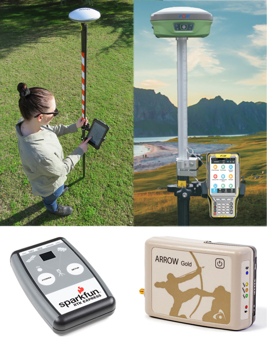
The four units put to the test (clockwise from top left): UAS Survey Gear ATAR (courtesy UAS Survey Gear); FOIF A90 (courtesy FOIF); SparkFun RTK Express (courtesy SparkFun); Eos Arrow Gold (courtesy Eos).
All were multi-frequency, multi-constellation, powered by internal batteries and RTK correction service-capable, but there was a wide range of price points (see Figure 1). The quality of the antenna and the multipath mitigation regime can be a distinguishing factor for low-cost GNSS receivers.
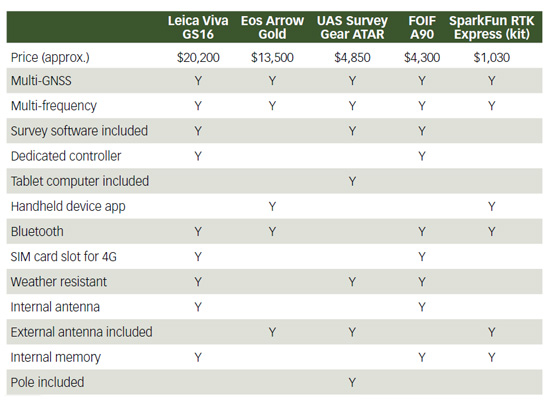
Figure 1. Technical attributes of the GNSS devices tested.
The students developed testing criteria based on experience and wider consultation — always conscious of the demands of the professional surveyor — and identified technical capability, hardware usability and software usability as their three main measures. They then located four testbed locations (Figure 2), each with both a clear and obstructed established survey control mark pair (eight marks in total) in the NSW SCIMS network (minimum Class B/LC).

Figure 2. Four testbed sites were used, each with a clear and obstructed established SCIMS mark.
Four tests were performed at each site for each of the five GNSS receivers, namely:
- Precise RTK observation: 2 minutes at 1-second sample rate repeated after more than 30 minutes.
- Rapid RTK: 3 epochs measured 10 times at same point.
- RTK time series: Log data at 1-second sample rate for an hour and analyse time series.
- Static observation: 15 minutes, 10° mask, 10-second sample rate, multi-GNSS, nearest CORS.
Technical capability
Technical capability relates directly to the four tests listed above. The students analysed precision (repeatability of solutions) and accuracy (proximity to the SCIMS coordinate).
Precise RTK observation: Surveyors are required to coordinate new or existing points, but regulations require double occupation separated by at least 30 minutes for the constellation to change geometry. Figure 3 shows a combined representation of all devices at all sites. All devices performed to a similar quality, with just a few outliers.
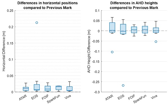
Figure 3. Comparison to SCIMS control: Position (left), AHD Height (right).
Rapid RTK: Surveyors often use RTK for detail surveys or for quick check shots. Figure 4 shows a compilation of observations for each receiver at clear versus obstructed sites for position and height. SparkFun showed outliers here.
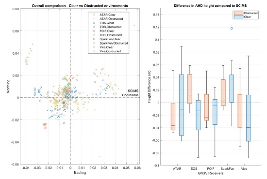
Figure 4. Comparison to SCIMS control: Position (left), AHD Height (right).
RTK Time series: This test gives an indication of slow, trending changes over time. The students produced many plots and tables of data. Two indicative time series from the most/least expensive devices is given in Figure 5. It can be seen in best case scenarios that both perform equally well in terms of accuracy and precision, with a height bias for the Leica device.
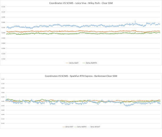
Figure 5. Comparison to SCIMS control: Leica (above), SparkFun (below).
Static observation: As per the parameters above, RINEX files were processed using Leica Infinity baseline processing software. Conversion to RINEX was sometimes difficult and ATAR and SparkFun were not able to be used in this test. The FOIF and ATAR receivers actually outperformed the Leica in this test, but the GS15 still produced acceptable results for survey applications.
Hardware and software usability
The ATAR gear has been designed with surveyors in mind. The kit comes with all the necessary ancillary equipment that a surveyor might need. This gear is designed primarily for RTK but can be configured for static observation. All software comes on a supplied tablet connected to the receiver via a cable. The functionality of this software is on par with survey grade receivers and quite user friendly. Exporting data is relatively simple and a range of data formats is on offer, however static data comes only in a proprietary HCN format which must be converted to RINEX (for instance). Problems were experienced with this step.
The FOIF A90 is a survey grade receiver with a built-in antenna, 4G modem for Network-RTK, micro-SD port, and Bluetooth and Wi-Fi connectivity that enables use with a tablet or controller. Students used a tablet to connect to the FOIF and third-party program (12d Field) via Bluetooth to enable NMEA messages. The configuration required to store the correct data for the various tests and for AHD heights (i.e. need N values) involves some expertise and is less user friendly. The device is field ruggedised and when correctly configured was applicable to most survey applications.
The SparkFun RTK Express is a very low-cost option and comes with minimal accessories and support. Poles, tripods, adaptors and so on were all customised from other sources to prepare the unit for the tests. An Android device was required along with the SW Maps application to connect the SparkFun to NTRIP for RTK corrections. Overall, using the SparkFun RTK Express was a very positive experience and, once correctly set up, it was extremely simple and intuitive.
Configuring the SparkFun RTK Express for static measurements and the time series tests for this research project was quite difficult. Issues with connectivity and then data formats had to be solved and the output data was in the form of latitude, longitude and ellipsoidal height. Students had to write Python script to convert to MGA (E,N), AHD for comparison purposes. This is obviously not desirable for a commercial survey operation.
The Eos Arrow Gold is a moderate-cost, multi-GNSS market entrant. The receiver was remotely connected to a laptop via Bluetooth and configured using the Eos Tools Pro app. Eos works as an auxiliary GNSS receiver for the connected device and ‘replaces’ the device GPS coordinate with the Eos solution. This presented problems for the tests in this project. Data had to be recorded by logging the NMEA messages using the Eos utility software for configuration, and the laptop needed to maintain internet connection to the NTRIP server. This was tricky and not very user friendly. That said, initialisation for Eos is lightning fast and coordinate quality was very reliable.
Similar to the SparkFun, the Eos logged latitude, longitude and ellipsoidal height and therefore required a Python script to convert solutions to MGA (E,N), AHD height using AusGeoid2020.
The Leica GS15 is a top-of-the-line survey grade GNSS receiver designed for the professional surveyor. The device comes with a high-quality antenna, an internal modem and external controller with all software and functionality available (although the number of options can complicate this usability). The observation/solution data can be configured to suit the needs of the professional surveyor and is easily converted to provide the desired format.
Conclusion
Modern GNSS receivers nowadays feature very similar GNSS engine hardware (chips), therefore it is not a surprise that the technical capability of the receivers was similar for the various tests. Positioning accuracy is not a strong differentiator for choosing between modern RTK receivers.
For the professional surveyor, the choice of receiver will depend more on factors such as system configuration, after-sales service, integration with existing systems, supported survey software, brand loyalty, price and suitability to the application.
Overall, this was a challenging and worthwhile student project, and it is hoped that readers may benefit from the findings. There is much more detail contained in the full student report; please contact the authors if you would like a copy. Many thanks to final year surveying students Jimmy Liu, Jamie Arcuri, George Gordon and Ronald La for their diligent data collection and analysis for this project.
Craig Roberts (c.roberts@unsw.edu.au) is Senior Lecturer in the University of NSW’s School of Civil and Environmental Engineering, while Peter Mumford (p.mumford@unsw.edu.au) is a Technical Officer in the School.
Stay up to date by getting stories like this delivered to your inbox.
Sign up to receive our free weekly Spatial Source newsletter.


