
More work needs to be done to properly employ spatial standards for the development of spatial digital twins.
By Sisi Zlatanova et al.
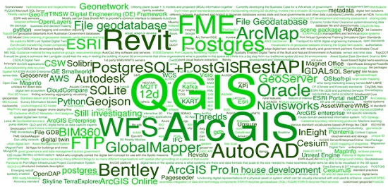
Over the period May to July 2022, the SSSI Spatial Digital Twin Special Interest Group (SDT-SIG) conducted an industry survey on geospatial standards for spatial digital twins (SDT). The survey aimed to form an understanding of how the Australian spatial community utilises spatial standards in the development and delivery of digital twin products and services.
The survey focused on the standards produced by three of the top international standards development bodies — the Open Geospatial Consortium (OGC), International Standards Organisation Technical Committee 211 for Geographic information/Geomatics (ISO/TC211), and buildingSMART International (BIM) — with 73 standards from OGC, 38 from ISO/TC211 and 12 from BIM being selected. The survey was completed by 42 respondents who were data decision-makers, data creators, users and other decision-makers from private companies, government bodies and academia. The resulting report provides a summary of the survey results and is available at https://geospatialcouncil.org.au/spatial-digital-twins.
Summary of survey results
The survey clearly shows that the understanding of, and use of, standards is still marginal. The general benefit of employing standards seems to be understood well, but specific knowledge is lacking. Only a few technical standards, which are adopted by software vendors and applied for data sharing, are well-known and largely used. The academic sector shows a slightly better interest in using and working with standards, but that is because many data modelling and sharing aspects are part of the research agendas of university groups. Furthermore, some researchers are directly involved in the design and modification of spatial standards.
The ISO standards are most used, followed by BIM and OGC standards. This may not come as a surprise since the ISO brand is a popular indicator of quality for most organisations. However, as the ISO standards need to be purchased, it would be interesting to investigate how an institution decides on the specific standard. Is the decision based on a recommendation from Standards Australia, ANZLIC or another governmental body? Are there cases where a standard has been purchased and never used?
Conflict points can arise when:
- Top-down decision-makers request standards without understanding requirements, the implications for databases/file formats, automation processes and existing schema relationships.
- Data producers are not given the time and resources needed to develop and maintain robust standard-based processes within the organisation, and deliver solutions that break standardisation rules or change them based on the organisational requirements.
An important aspect is human resources. Who is able to read, understand and implement the concepts, notations and procedures described in the standards? Are there graduates with geospatial degrees who can read these documents and implement them? It would be worthwhile to study which universities in Australia have included spatial standards topics in their curriculum.
Recommendations
The results clearly illustrate that it would be beneficial to provide a specification for which spatial standards are relevant for an SDT. Thus, organisations and governments could be given further indications of where in the production chain of SDT they belong, and which standards are relevant for them.
The results also indicate that there is a need to provide further guidance on the role and use of standards. Some standards (e.g. ISO 19115-1, OGC’s CityGML, WMS or WFS, BIM’s IFC) are related only to data and metadata sharing, which allow for bespoke data structures yet interoperable data exchange. There are standards that prescribe which kinds of vocabulary, semantics and attributes need to be used as well as how to model specific components of an SDT (e.g. walls in IFC). Other standards help perform transformations between two data structures (e.g. CityGML to IFC). It would be useful to categorise the spatial standards according to their applications in the SDT production line (data lifecycle): data collection, modelling, storage, exchange, visualisation and/or analysis. These categories can be further matched with the needs of the organisation.
Help in using standards can come from different directions: providing a classification about the nature of standards (conceptual or technical), helping with prioritisation in production, preparing guidance on how to use standards, and developing standard-compliant implementation specifications.
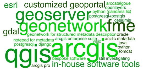
The survey attempted to investigate tools and services that support standards, but the results only indicated that a more elaborate study is needed. Usually, the software is used ‘as is’, without a deep understanding of whether the tools and services are standard-compliant. Moreover, users could benefit from understanding how standards can be amended, or how international standards can be adopted for their specific use.
Further understanding about the OGC standards must be developed. These standards are free documents and, for many OGC standards, non-OGC members can also participate by providing feedback and driving amendments. On the other hand, ISO standards are paid but hold greater official status and can be utilised to promote products and services as being compliant with official and recognised best practices as supported by a standards development body. OGC can have a corresponding ISO standard — this can enable users to test their implementation with OGC standards and then, if required by their organisational rules, obtain ISO documentation to ensure official compliance.
An interesting aspect, raised by some participants, is the interchangeable use of the terms ‘standard’ and ‘file format’. Almost every vendor has its own native format to export data, but not all file formats are necessarily a recognised standard. A typical example is the shapefile format. Any spatial schema can be exported as a shapefile. The shapefile can also carry information (geometry types, semantics and attributes) that is structured strictly according to a specific standard.
The issue is becoming even more complicated when 3D visualisation is needed. Depending on the type of file format, information (semantics, relationships, attributes, even some geometry types) can be easily lost. This is especially true when 3D game engines (such as Unreal and Unity) are employed. The visualisation file formats take care only of properties that are needed for rendering on the screen (e.g. geometry and colour/material). Furthermore, the rendering engines maintain more elaborate geometry data than GIS software. The link between specific file formats and standards needs to be clarified. In some cases, it may indeed appear that no standard is available, and a practical ad-hoc solution is employed.
Finally, the standards to be adopted need to be fit for purpose. Only in this way will it be possible to ensure quick developments of appropriate services, easy access to data (e.g. through APIs), transparent information about the quality of data, clear usage restriction and license obligations, as well as security and authentication. It should be also noted that SDTs should be integrated with many other non-spatial data, which means that the spatial communities need to interact with the broader standards to deliver an efficient spatial digital twin.
Authors: Sisi Zlatanova, Prudence Lawrence, Ivana Ivánová, Jack Barton, Soheil Sabri, Chris Body, Jinling Wang, Irina Bastrakova, Murray Doling, Stephen Neale, Saif Peerbux, Abdoulaye Diakite, Bahram Saeidian.