

SpaceX is targeting a launch date and time of 6:36pm Sydney time on Sunday, May 3 for its CAS500-2 flight.
Aboard will be a host of satellites from a range of clients, all for deployment into low-Earth orbit.
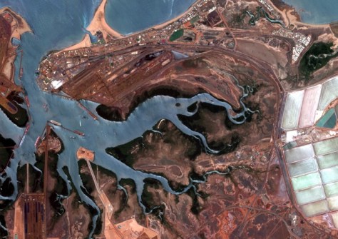
This includes three first-generation Pelican satellites for Planet Labs, each of which can capture 50cm-class imagery across six multispectral bands.
The Pelicans are equipped with NVIDIA’s Jetson AI platform to provide edge computing capabilities for on-orbit processing of data before it is downlinked to the ground.
Later this year, Planet Labs plans to begin launching its second-generation Pelican satellites, which will be capable of making 30cm-class observations.
Multiple payloads
Also aboard the upcoming SpaceX flight will be six satellites for EarthDaily Analytics.
The Canadian company claims that its imaging spacecraft have one of the highest pixel-processing capacities in orbit, able to digitise more than 20 billion pixels per second.
Each of its satellites carries 16 multispectral imagers — 12 visible and near infrared imagers (VNIR), two short wave infrared imagers (SWIR), and two thermal infrared imagers (LWIR) — plus visible spectrum (RGB), for a total spectral range of 22 bands.
The company’s first satellite was launched last year. After Sunday’s launch, the planned 10-spacecraft constellation will be completed with the launch of the remaining three satellites later this year.
Also aboard the flight will be:
- Eycore-1, a synthetic aperture radar satellite developed and built in Poland by Eycore;
- BSLT-3, a private Earth-observation satellite operated by Unseenlabs, taking the company’s on-orbit BSLT fleet to more than 20;
- GalaxyEye’s Drishti spacecraft, billed as carrying the world’s first OptoSAR payload, being a combination of a high-resolution synthetic aperture radar sensor and a 7-band multispectral imager;
- Three Forest wildfire detection satellites for OroroTech;
- Seven HEO (Hawk for Earth Observation) satellites for Argotec; and
- Two synthetic aperture radar satellites for ICEYE.


