

LiDAR scanning in the Caboolture area has revealed the scars of an ancient earthquakes.
The research, a joint effort funded by the City of Moreton Bay council, Unitywater and the Queensland Fire Department, uncovered the telltale signs of an earthquake the struck the region between 20,000 and 35,000 years ago.
After the fault line had been identified by Geoscience Australia, the council initiated what it says is the first project in Queensland to find evidence of other such past rupture events.
The project saw scientists from the University of Melbourne (UoM) use LiDAR to map the locations of past major earthquakes, with the expectation being that these spots might one day also be the sites of future quakes.
Uncovering mysteries
“Essentially, what we’re looking for are places where young sedimentary materials are broken by faults or pass across faults unbroken, and we can use those to guide studies to determine the timing and the magnitude of past earthquakes,” said UoM Professor of Earthquake Science, Dr Mark Quigley.
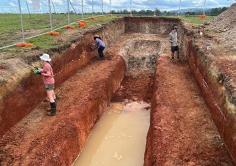
Following the LiDAR scans, excavations were made, and sediment samples were taken in an effort to understand the history of the event.
“This is effectively geological detective work; we’re uncovering the mysteries of these past earthquakes,” Dr Quigley said.
“We dug a trench perpendicular to the trace of the fault in the landscape, digging down several metres.
“We then mapped what’s been broken by those earthquakes in terms of the faults and what passed through that fault zone unbroken.
“Through dating techniques, we’re then able to get a picture of when this earthquake roughly occurred, how big the magnitude was, and how much displacement occurred at this location,” Dr Quigley added.
“From that we can build scenarios around earthquake hazards for all sorts of end users.”
Rare but dangerous
The council’s major, Peter Flannery, said the effort has been vital for constructing an understanding of the extent of potential damage from future earthquakes.
“It means we can not only better plan for the infrastructure needs of our community but also work towards how we respond to a future event,” he said.
Although earthquakes are relatively rare in Queensland, they still rank number nine on the state’s list of hazard priorities.
“The insights from this study will improve our preparation and preparedness, with data feeding into exercises performed alongside allied agencies and emergency partners,” said the City of Moreton Bay’s Local Disaster Management Group Chair, Councillor Matt Constance.
“This really detailed and accurate data, means we, as a Council, and our partners, are better prepared to serve our community in their time of need.”


