


Mobile mapping has revolutionised the capture of location and asset data for the road, rail and other sectors.
Search results for "asset management"
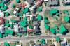
Nearmap starts production of new aerial solution
The company has completed the research and testing phase for its new HyperCamera3.

Vendor Focus: 1Spatial
In the lead up to Locate22 in May, we’re highlighting some of the vendors you’ll be able to meet.

A roadmap for critical national infrastructure
Geospatial resources, space development, data use and skills development are on Australia’s research agenda.

Industry leaders and rising stars recognised
The Victorian and New Zealand ASPEA winners have been announced, along with two new SSSI fellows.

How aerial imagery solves problems for outdoor events
MetroMap’s high-resolution aerial imagery and measuring tools are a game-changer for outdoor event managers.

New space tracking ground station for WA
Swedish Space Corporation will soon activate a new space situational awareness ground station north of Perth.

Landgate gives grants to location tech innovators
Six innovators will share in $150,000 to deliver outcomes from location data in the land admin sector.

Best of 2021: Q&A with spatial specialist, Inga Playle
Making a positive contribution to society and the environment is what drives Inga Playle’s work philosophy.

Interview: Port of Newcastle’s Robert Kelly
Hydrographic surveying is a critical component of keeping operations running at Port of Newcastle.