


©stock.adobe.com/au/YiuCheung
Mobile mapping has revolutionised the capture of location and asset data for the road, rail and other sectors.
By Peter Terrett
Mobile mapping has become commonplace due to advances in the technology enabling more users to take advantage of the accurate geospatial data it delivers. It is classic innovation where normally unrelated technologies are integrated to solve problems — and each of these technologies continues to develop, making the systems cheaper, more accurate, higher specification, smaller, lighter and using less power.
For more than 20 years, mobile mapping systems have been slowly developing. At first, they were expensive ad hoc systems built mainly in academic research establishments. An early system developed in the mid-1990s out of the university of Ohio for capturing highway assets, used GPS and differential wheel rotation to try to determine accurate location and orientation to locate objects in images. With the passage of time huge developments have occurred in GPS/GNSS, IMU, image quality, LIDAR, computers and so on.
When the systems started showing promise for commercial applications, some of the larger companies such as Trimble, Leica, Reigl and Topcon started developing their own commercial systems. Also, some smaller niche companies with expertise started to develop (in house) one-off or a small number of systems for delivery of data capture services.
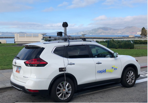
For the purposes of this article, mobile mapping systems are described as vehicle-mounted sensors for corridor (eg. road, rail etc) mapping comprising a range components that may include:
- High-performance GNSS typically integrated with IMU and distance encoders for land vehicles (wheel mounted or digital from the vehicle wiring) enabling Direct Georeferencing (DG).
- Digital cameras, typically 360° cameras (asset capture, digital twins) but may also include high-resolution cameras for specific data capture, such as road surface defects, that many be extracted by machine learning algorithms.
- Trigger box to synchronise location against data captured.
- High-specification computer.
- A range of software both in the vehicle and for processing the data to a final product.
Other sensors for mobile mapping can include LiDAR, radar, multi-spectral cameras, hyperspectral cameras, and infrared and thermal cameras.
The masses of geospatial data created cost effectively and at highway speed, has contributed enormously to the location bases information available to a variety of end users. Data captured once can be accessed by multiple users for a variety of purposes, thus leveraging the investment.
For instance, a road surface and roadside assets data capture in one pass serves initially two purposes: Road defect survey for maintenance activities, planning and risk management, and traffic control and street furniture audit.
However, with the recent floods, data before the flood provides a snapshot of the existing condition and assets that can be used for reinstatement/rehabilitation of the network, as well as for proving the condition prior to the flood event for gaining federal or state funding post disaster.
A mobile mapping survey after the floods (or fire or cyclone) can also provide timely and detailed information to best address priorities to apply the response resources.
Mobile mapping is the ‘all seeing eye’ that can capture the streetscape, so that you can know, for instance, that at that time a crossover was in good condition and that subsequent building works have damaged it. This can aid in getting the contractor to pay for the damage they caused.
Location is best achieved using a high-performance, multi-frequency GNSS, tightly integrated to an accurate IMU and a distance encoder. These systems are known as Positioning and Orientation, and they make possible the DG of any object that appears in two or more images without any further field survey.
The IMU can detect changes in location and velocity of a moving platform in six degrees of freedom and report these measurements back into the system 200 times per second. Coupled with the distance encoder, you have a precise ‘dead reckoning’ system. The GNSS is used to anchor the location to accurate real-world coordinates. The IMU and distance encoder allows for positioning to continue in GNSS harsh environments such as cities, tunnels and heavily vegetated road corridors. Without the GNSS to update the locations, there is progressive decay of the location data provided by the IMU and the accuracy will then be related to the quality of the IMU. Manufacturers such as Applanix focus solely on developing these integrated GNSS and IMU systems.
Digital camera technology has come a long way in 25 years. It is now possible to have a 6 x 31 MP camera system (Mosaic Viking) that can take 5 images each per second. This means you have the ability to travel at high speed and still have high-resolution images that you can run through machine learning algorithms to detect road defects, line markings and their condition, signage and other road furniture and so on. It is all about the efficient collection of large amounts of accurate data.
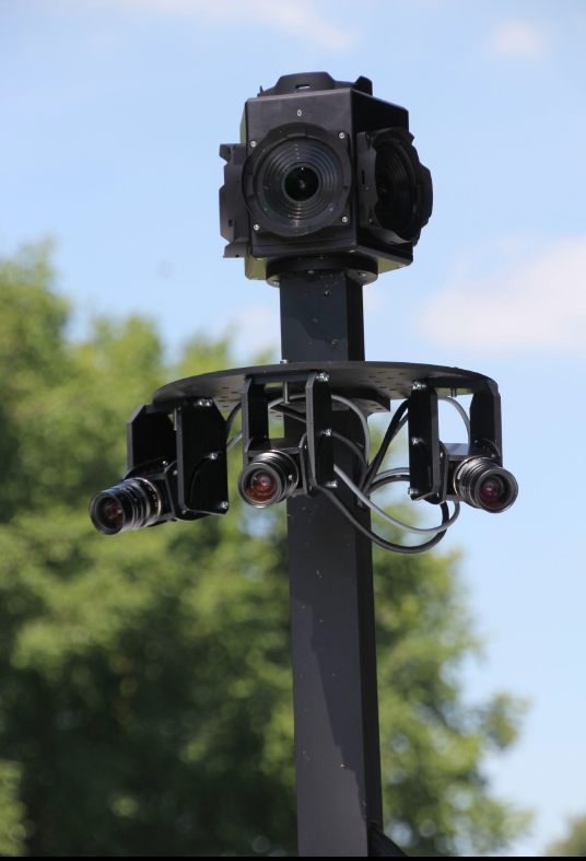
Lady Bug 360 and Grasshoppers HR cameras.
Just as drones have quickly become a cost-effective way to capture large amounts of accurate data, so too have vehicle-mounted mobile mapping systems, which can now outpace traditional surveying methods because of their cost-effectiveness and speed. They are much more effective in offering comprehensive environmental solutions that are easy to visualise, measure and analyse landscapes, features and objects.
As in photogrammetry, any objects image taken from two geographic locations can be accurately located and measurements taken. High-quality images can also provide details of condition and other attributes.
As always, technology continues to evolve. Machine learning now makes it possible to teach a computer what certain objects in images and point clouds are, such as assets (signs, poles, line markings) and defects (potholes, delamination, cracking etc of pavement). Much work is being done in this area.
Some recent work undertaken by Rapid Map and its partners in Europe is showing significant promise with Australian-standard signs, road markings and road pavement defects. With a shortage of engineers, being able to transfer expertise to a ‘machine’ and do in hours what would take a human literally weeks, will provide benefits in lowering the costs of operating a road network.
It is hard to conceive of all the applications that mobile data can fulfill, but once captured it can be used for:
- Military
- Smart cities
- Asset identification and management
- Post disaster assessment
- Asset maintenance
- Street scapes
- Heritage overlays
- Vegetation encroachment
- Condition assessments
- Audits
- Change detection
- Gaming environments
One report says “The market for global mobile mapping systems was valued at USD 21.3 billion (28.5 billion AUD) in 2020 and is expected to reach a market value of USD 63.32 billion (85 billion AUD) by 2026 and grow at a CAGR of 22% over the forecast period 2021-2026. The Asia-Pacific region is said to see the fastest growth, while North America and Europe will see substantial growth”.
Benefits of using mobile mapping
Speed: Travelling at 80 kilometres per hour equals about 22 metres per second. Taking four high-resolution images per second means an image taken every 5.5 metres.
Efficiency: Mobile mapping systems improve your capture efficiency. Vast amounts of data for a variety of users and uses can be collected in one pass.
Accurate: Properly trained operators with high-quality equipment set up appropriately for the job will produce consistent, high-quality data. It is important to stress that the quality of the IMU in urban environments directly affects the positional accuracy, and the quality of the cameras directly affects the usefulness of the data.
Safety: Rather than setting up to scan an environment on the edge of a roadway, the safety of collecting data from within a vehicle travelling at highway speed makes for a much safer project. It also lowers the cost by not needing traffic control.
Flexibility: Adding different sensors to the core positioning systems provides flexibility for different client’s needs. In the end, the customer can pick the accuracy level that fits their needs or mix and match accuracy levels for individual spaces throughout the asset.
This has been a brief overview of systems and uses; I did not even cover the latest hot topic of digital twins, which is a significant area of growth for smart cities using mobile mapping technologies. Possibly a subject for a future paper.
Peter Terrett is a GNSS consultant with more than 35 years hands-on experience. He started 4D Global Pty Ltd in 1991 (then named as Global Star) and has provided hardware, software, training, and consulting services to thousands of professionals throughout Australia and beyond. 4D Global is part of the Rapid Map Global Group of companies.
This article was first published in the Apr/May 2022 issue of Position magazine.
Stay up to date by getting stories like this delivered to your inbox.
Sign up to receive our free weekly Spatial Source newsletter.


