


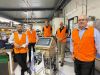
Veris reached out to Leica Geosystems to upgrade their existing MLS systems with the new Leica Pegasus:Two Ultimate Mobile Sensor Platform.
Search results for "asset management"
Esri Directions Live Online webinar series featuring 1Spatial
When:
18 February, 2021 @ 12:30 pm – 1:00 pm
Where:
Online Webinar
From barrier to enabler: Smarter data management From 3D data to real-time feeds – organisations have access to more information than ever before – but without effective data management systems in place, realising the true[…]

Pix4D, SAP partner on 3D transmission mast inspection
Pix4D and SAP announce new integrated offering aimed at automated asset inspection for telcos.

Mobile Software from Global GBM – Product Review
Industry specialist Bruce Douglas reviews Konect, an innovative mobile field services and mapping solution from Global GBM.
Read full story • Comments are closed
12d Tech Forum 2021 | Online Industry Summit
When:
19 October, 2021 – 21 October, 2021 all-day
Where:
Virtual Event
Hosted by 12d – the companies behind 12d Model and 12d Synergy – the highly anticipated 12d Tech Forum returns on 19 – 21 October 2021. The three-day online industry summit will connect over 2,000[…]
Engineers Australia launches Covid-19 recovery plan
Engineers Australia has called for a greater response to protect health, livelihoods and the infrastructure sector.
SICC Webinar: Reporting and Measuring Bushfire Mitigation Work, a Software Pilot
When:
28 April, 2020 @ 12:30 pm – 1:30 pm
Eugene Lamnek created GeoIT Solutions in 2002, and has been developing ArcGIS customizations, add-ins and applications ever since. In this time Eugene has developed numerous bushfire applications for the CFS and the CFA as well as[…]
Postponed – International Lidar Mapping Forum
When:
23 March, 2020 – 25 March, 2020 all-day
Where:
Walter E. Washington Convention Center, 801 Mt Vernon Pl NW, Washington, DC 20001, United States
Why Attend? International Lidar Mapping Forum (ILMF) is a technical conference and exhibition showcasing the latest airborne, terrestrial, and underwater lidar as well as emerging remote-sensing and data collection tools and technologies. With a special emphasis on[…]
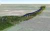
BIM to build a digital railway from scratch
Digital Rail Baltica is on its way, with 870km of tracks and 400+ bridges and other structures.

Singapore to host regional show
Geo Connect Asia 2020 aims to harness the pivotal position of geospatial information in South East Asia’s growing knowledge economy.