

An Australian-invented remote controlled surveying helicopter is being used in oil and gas exploration, war zones, law enforcement, and… by a Perth real estate agent to sell property in WA. The CyberQuad, invented by 27-year old Joshua Portlock and built by WA company Cyber Technology, is a 4-blade helicopter equipped with a high […]
Search results for "UAV"
SouthPAN’s serious accuracy boost for NZ forestry
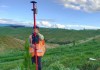
SouthPAN lets the Bioeconomy Science Institute gather more data, more quickly and with better accuracy.

Beca acquires environmental firm CQG Consulting
Queensland-based CQG conducts a range of environmental activities, with strengths in GIS and surveying.

Turning image quality into decisions, not delays
An automated system handles imagery that’s compromised by haze, fog or atmospheric conditions.
AlphaAir 6 takes off into the aerial LIDAR market
The unit is designed for UAV-based laser scanning, LiDAR mapping, and aerial surveying in high-relief terrain.

Cert IV in Surveying to start in the ACT in 2027
The course means that the ACT will once again have a source of Associate Surveyors, after a nine-year drought.

Measuring rockfall debris accumulation with LiDAR
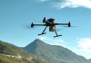
A research team has measured rockfall debris accumulation from steep slopes using drone-carried LiDAR.
Young Professionals interview: Sijan Bhandari
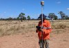
Sijan Bhandari’s journey as a surveyor has taken him from Nepal to mining sites in the Queensland desert.
ML-based automatic point cloud and image analysis
Blue Marble Geographics recently debuted its Global Mapper Pro version 26.0 with exciting new features.

Achieving mine surveys in weeks, not months
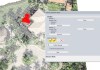
How Revolver Resources made its Dianne copper mine project more efficient with Mangoesmapping.