


Leica’s newest capture solution facilitates onsite processing and inspection of scans.
Search results for "GIS"

Big changes in TatukGIS Editor V5
TatukGIS says the upgrade lifts it to the level of the more powerful TatukGIS Developer Kernel version 11.

GIS People wins $500k grant for rapid damage assessment system
The award for the firm’s RADAR app was granted under the federal Accelerating Commercialisation program.

In depth: tackling flood management with GIS
Queensland’s Banana Shire Council have used GIS to transform their response to flood events.

Last change to register for 2018 Precision Agriculture Expo
The 2018 Precision Agriculture Expo will take place in Crystal Brook, SA, on March 21.

TatukGIS releases software development kit for Java
Java developers rejoice: extensive GIS-focused SDK released by Polish software house TatukGIS.

Google’s geospatial technologist – Q&A with Ed Parsons
Google’s geospatial technologist sits down with Spatial Source.
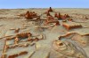
Archaeologists uncover 60,000 Mayan structures
Use of LiDAR instrumental in uncovering of ancient cities beneath the Guatemalan jungle.

Early bird registration now open Locate 18 – Geosmart Asia 18
Participants can reap a solid discount until January 31.

