


NASA and CNES will jointly conduct a survey of Earth’s surface water and ocean surface height.
Search results for "CNES"

Who controls Australia’s geospatial sector?
Igor Stjepanovic ponders what Australia gains and loses when strategic geospatial ownership moves offshore.

Sentinel-6B satellite set to survey sea levels
Sentinel-6B is equipped with an improved dual-frequency radar altimeter and microwave radiometer.
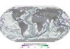
Ocean height data used to map the seafloor below
SWOT satellite data is revealing thousands of seamounts, potentially doubling the number previously known.

Next Sentinel SAR satellite arrives at launch site
The Sentinel-1C synthetic aperture radar satellite is due to replace the failed -1B in Earth orbit.

Sentinel-2C reaches orbit to replace Sentinel-2A
The Earth observation satellite will image the planet in 13 spectral bands with a swath width of 290 kilometres.
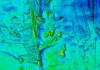
Bathymetry, remote sensing probe deep ocean
The voyage aboard the RV Investigator surveyed 20,000 square kilometres to a depth of 4,000 metres.
The low Earth orbit revolution
Low Earth orbit satellite observations are accelerating society’s journey towards sustainability.
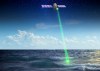
Bass Strait’s role in SWOT satellite mission
Australia’s Integrated Marine Observing System is using GNSS-equipped buoys to help measure ocean topography.

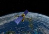
Environment-monitoring instrument reaches orbit
Argos-4 takes its place in the system that captures, processes and distributes environmental data.