

Almost two centuries of surveying history are maintained and displayed at the Museum of Lands, Mapping and Surveying.
By Kaye Nardella
Queensland’s earliest surveyors faced many challenges — extreme weather conditions, harsh terrains, long distances travelled, wildlife and fauna which included crocodiles, insect infestations, and so much more.
Today, the stories, maps and tools of these surveyors and cartographers are preserved at one of the most comprehensive digital and physical collections of maps and artefacts in the world — the Museum of Lands, Mapping and Surveying, located in Brisbane.
Opened in 1982, the museum has an extensive collection of original material, artefacts, photographs and published material. It can also access government materials including maps, survey plans, aerial photographs and land records.
This article presents some of those fascinating artefacts and images, and the stories that go with them.
A look back in time
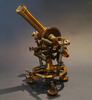
Figure 1 (at the top of this web page) shows a 7-inch Bamberg theodolite held by the Museum. This theodolite played an important role in confirming the Queensland/Northern Territory border. It was used in 1885 by Queensland Staff Surveyor Cecil Twisden Bedford to help check the longitude of the earlier border survey as carried out by South Australian surveyors, Poeppel and Carruthers. Bedford first determined the longitude of the telegraph station at Boulia from the datum of Sydney Observatory and then conducted a traverse survey from this point to the Queensland/Northern Territory border at Tobermorey, to confirm that the longitude of the border was 138o east.
Figure 2 shows ‘We of the Survey,’ an illustrated poem created by John William Sorby around 1890. It is a humorous look at the surveying profession captured in 24 verses. At the time, the artist was a chainman for William Daniel Cooke during his survey for the Mackay-Bowen Railway.
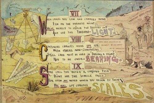
Figure 3, one of the 7,000 historical photographs held by the museum, shows surveyor James Reibey Atkinson and other men at a coal mine at Ipswich, around 1870. Atkinson was a land, railway and sometimes mining surveyor. Note the mining dial at right and the broadband steel tape held by the man in the centre.
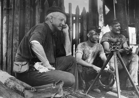
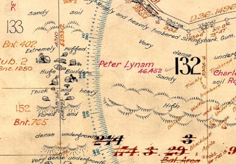
Figure 4 shows survey plan BNT478, which captured a 1914 survey by Claude Newcombe of Portions 129 and 132 in the Parish of Broadwater (southwest of Stanthorpe). It described the area as having ‘sandy soil … very thickly and heavily timbered Stringybark, Gum, Blackbutt and Pine’. The cartographer drawing the survey plan added some illustrations of men who appear to be playing hide and seek amongst the ‘Huge Boulders’.
Life in the field
In 1839 the first three surveyors, Robert Dixon, Granville Stapylton and James Warner were sent from Sydney to Brisbane to commence surveying in what became Queensland, to support the colonial government’s desire for free settlement in the area. They conducted feature surveys and trigonometrical surveys for survey control, cadastral surveys and undertook mapping. These steps were critical to enable the subdivision and sale of land. Instructions were provided to surveyors to capture soil types, vegetation and any existing features or improvements, for example footprints of buildings. For surveyors, it was about gathering information to support the management of land and development. The information captured on these survey plans has tremendous historical value.
An interesting oddity was noted by surveyor H.B.R. Harrison as part of his 1883 survey of an area near Belyando River and Mount Gregory (northwest of Clermont). He recorded on survey plan K103657 sheet 1, ‘Subterranean noises frequently heard here’ near Mount Gregory. By 1938, this had been embellished on a Queensland four-mile series cadastral map (4m71) with the addition of ‘Like a roll of Artillery’.
Surveying life could be challenging. New South Wales Surveyor-General Sir Thomas Mitchell explained in 1855, when describing the pioneering efforts of his department (which included surveyors working in Queensland), that ‘… the work of those days, in tracing rivers and ranges, was about the most onerous of our duties’, and the isolated, itinerant life had lost him many good surveyors ‘from the odious habit of Drunkenness’ (Source: T.L. Mitchell, in ‘Minutes of Evidence Taken before the Select Committee on the Management of the Survey Department,’ V&P of the NSW Legislative Assembly, 1855, vol.2, p26). Some early field books held by the Queensland Department of Resources record lists of supplies to be ordered, including alcohol.
Suveyors working in the field had to be versatile and innovative. Wire was an important part of a surveyor’s kit as it could be put to valuable uses. For example, it could be bent into a U shape and used as a ‘spiderweb catcher,’ as spiderweb threads in earlier times were used as crosshairs in surveying equipment. If the crosshairs broke while the surveyor was out in the field, he would bend wire into a U shape, locate a spider, encourage the spider onto the catcher, turn it and collect the thread as the spider dropped. This thread would then be added to the reticule of the instrument and the surveyor was back in business. (Hopefully the spider was gently sent on its way after its assistance.) The museum has three spiderweb catchers on display.
The efforts of surveyors in gathering information were captured in field books and recorded on survey plans, information that was the building block for creation of maps and for land administration in Queensland. The types of maps created include cadastral maps (showing property boundaries and property descriptions), topographic maps (showing relief and features) and themed maps.
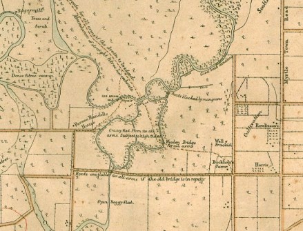
Figure 5 is a portion of an 1889 map that is one of the earliest topographic maps drawn over Queensland. It was created by the Queensland Defence Force and covered the northeast area of Brisbane. The need for this map was spurred by concern that the Russians were expanding into the Pacific region. Its military purpose was reflected in the details added: for example, ‘Route available for all arms if the old bridge is in repair’. The map’s historical value is shown with the annotation of features such as the Sugar mill, the location of buildings and the names of owners of farms.
Preserving the past
The Museum of Lands, Mapping and Surveying’s role also includes digitising and making discoverable material such as these historical maps, plus engagement and historical land research. For example, more than 11,000 historical map scans can be accessed for free via the Queensland Open Data platform and via a Historical maps topic available from the Queensland Globe.
A future task is to investigate traditional knowledge in mapping and land management.
The Museum is located at 317 Edward Street, Brisbane, and is open Monday to Friday from 9:30am to 4:00pm. It can also be accessed virtually via the Museum’s website. You can also follow the Land Queensland Facebook page for more stories on the history of surveying in Queensland.
Kaye Nardella is Senior Curator at the Museum of Lands, Mapping and Surveying | Spatial Information, within the Queensland Department of Resources.
This article was first published in Issue 129 (Feb/Mar 2024) of Position magazine. Please consider subscribing.


