

The UK’s Geospatial Commission has partnered with The Alan Turing Institute to explore the role that artificial intelligence can play in long-term decisions about how to best use land.
With the UK facing pressures on land use, it is hoped that advances in spatial data science and technologies, such as AI, can open up opportunities and help solve the trade-offs surrounding land use change, such as through scenario testing and visualisation.
“We face growing pressures on our limited supply of land, from the need for new housing to tackling challenges like climate change and food security,” said Viscount Camrose, Minister for Artificial Intelligence.
“By harnessing innovative technologies like AI, we can support more effective long-term decisions about our land and ensure we are maximising its use and so I welcome this ongoing collaboration between the Geospatial Commission and The Alan Turing Institute.”
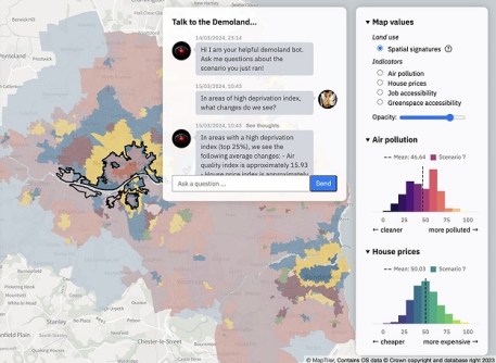
The Geospatial Commission has been in partnership with The Turing on land use since 2022. Their work led to the development of a prototype tool in June 2023, which leveraged data science and AI to visualise different future scenarios for land use in collaboration with Newcastle City Council.
The partnership is now further developing the prototype tool, incorporating national satellite data and vision foundation models for improved accuracy and analysis via AI. It is also incorporating a large language model approach, which will make the tool more accessible for non-technical users.
The underlying model will be available for public download at the conclusion of the project later this year.
“The way we use land will be more crucial than ever in the years ahead as the UK targets economic growth and prosperity whilst ensuring we protect the environment and adapt to climate change,” said Jean Innes, CEO of The Alan Turing Institute.
“It is exciting to see the partnership between the Geospatial Commission and The Turing develop, augmenting current scenario modelling tools with new geospatial AI capability, applying satellite data and large language model technology to help more cities and regions make effective decisions about land use.”
The UK government has invested more than £3.5 billion in AI over the course of the last decade, including a recent doubling (to £100 million) of its investment in The Alan Turing Institute.


