

Check out our regular compilation of geospatial news snippets from across Australia and around the world.
NASA Earth science data now in ArcGIS Living Atlas
By jnally on 22 January, 2025The Living Atlas of the World now features NASA data formatted specifically for GIS users.
Certified GIS Professional exam dates announced
By jnally on 22 January, 2025The GIS Certification Institute has set the testing window for its Geospatial Core Technical Knowledge Exam.
Terria promos 2025 digital twin partner program
By jnally on 22 January, 2025The Program will including hands-on collaboration and the ability to trial advanced digital twin technology.
Data and mapping for natural disasters
By jnally on 21 January, 2025Data visualisation and mapping have a vital role in preparing for and responding to hazards and disasters.
Vexcel to provide aerial imagery for Lloyd’s Market
By jnally on 20 January, 2025Vexcel will offer its aerial imagery, geospatial data and property attributes services, including post-disaster images.
Interview: Samantha Garbutt, Australian Spatial Analytics
By jnally on 20 January, 2025In our annual Leaders Forum, we ask the experts to look ahead into 2025. Today we talk workforce with Samantha Garbutt.
User feedback sought on Digital Twin Victoria platform
By jnally on 15 January, 2025Digital Twin Victoria is seeking input from the geospatial sector to ensure the platform is meeting user needs.
Latest Geospatial News
View all
Rubinov has made major contributions to Australia’s first Positioning, Navigation, and Timing Labs.
 2025-05-13
ADVERTISEMENT

The cash transaction values FARO at an enterprise value of approximately US$920 million.
2025-05-13 
Australian Stuart Minchin has received a lifetime achievement award at the 2025 GEO Awards in Rome.
2025-05-12 
Mark Briffa has joined the University of Melbourne’s spatial data and land administration research centre.
2025-05-12 
The Ordnance Survey will use the Trimble R980 GNSS receivers to upgrade its national survey network.
2025-05-09 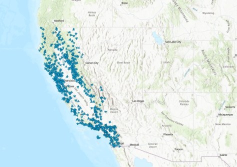
A new layer in the ArcGIS Living Atlas of the World links to the feed from more than 1,150 wildfire cameras.
2025-05-07
ADVERTISEMENT

Students will be offered internships with the IGNIS project, which is mapping heat and lightning across WA.
2025-05-07 
- Sponsored Content
Aidedo was founded based on the practical experience of CEO Aiden Tong while studying and working with many Civil Engineering and Land Surveying firms in developed countries.
2026-06-02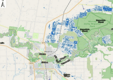
SmartSAT CRC, industry and academia are using satellite radar and optical data to quantify major flooding events.
2025-05-06 



Events
View All-
Nov 9
2026 Advancing Earth Observation Forum
 Hobart, Tasmania
-
Nov 10
SouthPAN Industry Day
Online -
Nov 13
South West and Great Southern Surveyors Conference
Mantra Bunbury Lighthouse, Bunbury, WA -
Nov 24
Locate26 Conference / 10th Digital Earth Summit
Melbourne Convention & Exhibition Centre -
Nov 30

