

Vexcel Imaging has announced a new partnership with London Market Operations and Strategic Sourcing Limited (LIMOSS), under which it will offer its aerial imagery, geospatial data and property attributes services to the Lloyd’s Market.
The deal began on 1 January, with Vexcel’s products and platform now available as a LIMOSS elective service.
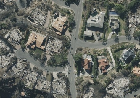
The partnership will enable Lloyd’s Managing Agents tap into a detailed imagery and property intelligence data from Vexcel’s UltraCam sensors and dedicated fleet of aircraft.
The Lloyd’s Market comprises more than 50 insurance companies, more than 380 registered Lloyd’s brokers, and a global network of more than 4,000 local coverholders.
Vexcel provides high-resolution aerial imagery and geospatial data across more than 40 countries, including Australia, the USA, Canada, the UK and Japan, and countries in Western Europe and other regions.
In addition to its imagery collections, Vexcel also provides post-catastrophe imagery of properties affected by events such as fires and cyclones.
“While we have a small segment of the Lloyd’s Market using our platform today, we are excited to showcase our extensive aerial imagery and data library to a broader segment of the Market, offering insurers quick access to valuable, ready-to-use imagery and insights to enhance decision-making across their policies,” said Glen Brooks, SVP of Insurance at Vexcel.
“We are excited to provide choice for imagery and imagery analytics to the world’s leading insurance market.”


