

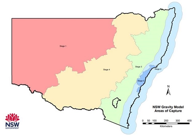
DCS Spatial Services’ airborne gravity mapping project will be conducted in five stages. Image courtesy DCS Spatial Services.
NSW DCS Spatial Services has begun capturing data for a statewide gravity model, using an aircraft equipped with an airborne gravity sensor to fly lines in 2-plus-km spacings across the state.
The NSW Gravity Model will cover the whole of NSW — a geographic extent of more than 800,000 square km — and will deliver a new level of coverage and accuracy. The current dataset has distinct limitations, and includes a combination of land-based, satellite and airborne gravity data collected over several decades.
The NSW Gravity Model will significantly improve the quality and accuracy of 3D positioning, and will form one of the critical building blocks for an accurate and reliable foundation upon which current and future 3D and 4D digital twins can be built.
The improved Gravity Model will help land managers understand groundwater stores, enable engineers to identify where major natural hazards may occur and help surveyors measure height more accurately.
Stage 1 of the effort will cover the far west of the state, Stage 2 the coastal zone, Stage 3 the western slopes, Stage 4 the central west, while Stage 5 will focus on the heavily populated areas along the eastern seaboard.
The gravity measured for the model is constant, meaning that it can be measured once and utilised forever, ensuring the model will be future proof for years to come.
Stay up to date by getting stories like this delivered to your inbox.
Sign up to receive our free weekly Spatial Source newsletter.


