

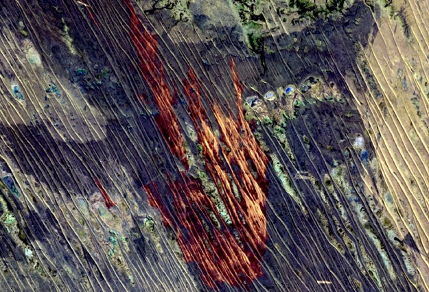
Image courtesy Queensland Government
Scientists have developed an improved way of using satellite imagery to map where fires have occurred across Queensland, boosting the state’s fire management capabilities.
The new method uses Sentinel-2 imagery combined with machine learning and operational mapping technology to produce monthly, high-quality, state-wide maps of areas affected by fire.
The Sentinel-2 satellites capture imagery for all parts of Queensland every five days, meaning the regularity of the monitoring will be frequent enough to capture most fires as they occur, providing a resource that will complement active fire maps.
The method, developed by the Department of Environment and Science (DES) and the Joint Remote Sensing Research Program, builds on previous work which mapped Queensland’s fire history using Landsat satellite imagery.
“Understanding exactly where and when a fire has occurred will help us to improve our predictive fire modelling capabilities, assist in the development of planned burn or hazard reduction programs, and allow us to monitor the ecological impacts of fire on biodiversity, land condition, water and air quality, and better quantify our greenhouse gas emissions,” said Queensland’s Minister for the Environment, Meaghan Scanlon.
“This tool enhances QFES’ predictive services capability in the generation of bushfire intelligence and mitigation strategies,” added Queensland Fire and Emergency Services Commissioner, Greg Leach.
“It is a key component of QFES’ fire history data set which is used to inform our fire modelling technology and predictions as they occur by considering the available fuel on that landscape for the fire to consume.
“Knowing what areas have burnt previously also provides vital hazard reduction burn considerations as we work with our partners, including the community, to mitigate the risk of bushfires.”
Fire scar maps will be delivered monthly and are publicly available through the Queensland Government’s Open Data portal and the North Australian Fire Information portal.
Stay up to date by getting stories like this delivered to your inbox.
Sign up to receive our free weekly Spatial Source newsletter.


