

A new mobile scanning kit enables anyone on a team to capture accurate 3D scans with a smartphone.
PARTNER FEATURE
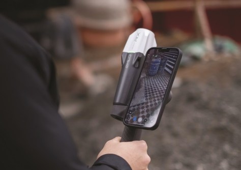
To streamline and accelerate complex field-to-office workflows, Emlid and Pix4D are launching a mobile scanning kit that will enable anyone on the team to capture accurate 3D scans with a smartphone, the new PIX4Dcatch app, and an Emlid Reach RX RTK network rover.
A plug & play solution
The recently upgraded PIX4Dcatch app is at the core of the software part of the kit, offering a streamlined, precise terrestrial photogrammetry and LiDAR (if using a LiDAR-enabled smartphone) scanning solution.
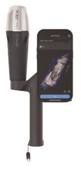
The hardware part features the Emlid Reach RX RTK network rover, equipped with an ergonomic handle and accessories. Paired with a smartphone, the kit creates a compact and cost-effective scanning solution.
The Emlid Reach RX is natively integrated with PIX4Dcatch Pro and provides RTK GNSS survey quality positioning via NTRIP corrections. To begin scanning, simply select a pre-configured profile for the Emlid device in the RTK settings of PIX4Dcatch Pro and add your NTRIP network credentials.
The solution’s design eliminates the need for additional hardware setup or specialised skills. Anyone on the team can use the kit, ensuring effective data collection as they move around the asset.
Cross-industry workflows
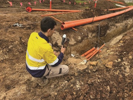
Easy to deploy yet highly accurate, this scanning kit will become an asset for professionals and non-surveyors in a range of applications:
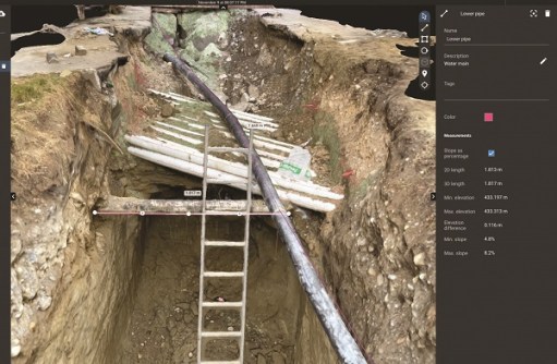
- Underground utility documentation and as-builts for companies implementing Subsurface Utility Engineering (SUE) best practices.
- Construction inspection: As-built scans to design plans and expedite approvals.
- As-built surveys: A better as-built with less time spent on data collection and drafting.
- Volumetric measurements: Effortlessly quantify stockpile volumes.
- Crash reconstruction: Perfect for clearing roadways quickly with easy, accurate scans.
- Combined aerial and terrestrial surveys: Complement overhead drone captures with terrestrial PIX4Dcatch scans.
Hardware: GNSS by Emlid
The Emlid Reach RX works with any NTRIP correction network broadcasting RTCM3. The rover gets a fix solution in under 5 seconds even in challenging conditions and ensures centimetre-accurate positioning.
Apart from providing accuracy for the scanning tasks, it can be used with a survey pole as a powerful and lightweight network RTK rover for data regular survey and stakeout.
Designed for urban areas, the Reach RX has the following specs:
- Rated IP68, it is sealed and protected from water and dust.
- The receiver weighs 250 grams and can be carried in your pocket.
- An industrial-grade battery handles both high and low temperatures and provides 16 hours of work from a single 3-hour charge.
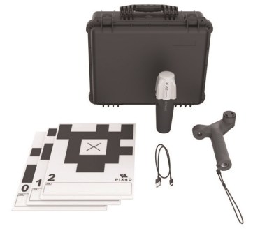
Besides the Emlid Reach RX, the Emlid Scanning Kit includes additional accessories: the Emlid scanning handle with a leash, five Pix4D Autotags and a carry case.
Software: PIX4Dcatch app
The PIX4Dcatch app enables you to scan with a compatible smartphone and obtain a digital 3D model in minutes. It comes in different versions to better adapt to your needs.
The PIX4Dcatch Standard app enables users to collect data that can be processed into 3D models with your existing Pix4D software licence (PIX4Dcloud, PIX4Dmatic or PIX4D mapper).
A PIX4Dcatch Pro subscription is required to enable RTK features, along with automatic target detection (Pix4D Autotags), augmented reality (AR) features, CAD file overlays, on-device volume and distance calculations, and staking capabilities.
Try the scanning kit
Map Gear, the official Emlid dealer in Australia, has already tested the new PIX4Dcatch app with the field-proven Reach RX receiver and shared its first impressions.
“This is indeed a game changer for multiple industries. Emlid and Pix4D have created an extremely easy-to-use, yet survey grade solution for terrestrial scanning in a financially accessible format,” says Alistair Hart, General Manager at Map Gear.
“Now, those working in construction, utilities, forensics, or drone mapping can build highly accurate 3D models without the need for third-party surveyors. In addition, the entire workflow, from data capture to final deliverables, has become many times faster.”
For full details on the Pix4D & Emlid Scanning kit, visit mapgear.com.au or email sales@mapgear.com.au.


