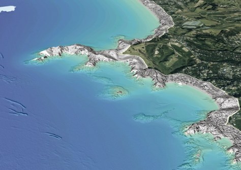
Taking in both the North and South Islands, the flights are part of the plan to map 40% of NZ’s coastline in 3D.
Specialist survey aircraft taking to New Zealand’s skies again this month to map coastal areas across the North and South Islands.
The flights are part of Toitū Te Whenua Land Information New Zealand’s (LINZ) 3D Coastal Mapping program, which aims to map up to 40% of New Zealand’s coastline using LiDAR and multi-beam echosounder technologies.
Program Lead, Stuart Caie, says the information will help build a clearer picture of New Zealand’s coastal environment and the risks it faces.
“New Zealand’s coastline is exposed to natural hazards including tsunamis, storm surges, erosion, land movement and earthquakes,” he said.
“By creating a clearer picture of the coast, this information will help communities understand what may be at risk and support councils and other organisations to plan infrastructure and essential services for the future.”
The data gathered will support the production of detailed maps of the coastline, across the land and seabed in shallow water. The areas being surveyed have been selected because they have substantial populations, important infrastructure, or are at higher risk of coastal flooding.
The flight campaign is planned to run from early November 2026 to May 2027, according to suitable weather and water conditions. Those interested can follow progress via the online 3D Coastal Mapping Progress Tracker.
The areas to be covered include coastal parts of Auckland, Waikato, Gisborne, Bay of Plenty, Hawke’s Bay, Manawatū-Whanganui, Wellington, Southland, Canterbury, the West Coast and Marlborough.
As Spatial Source reported last week, LINZ is seeking new members to join its 3D Coastal Mapping Advisory Group.
The aim of the Group is to gather extra expertise and perspectives to help show how high-resolution data of the coast and seafloor can support hazard modelling and planning, climate adaptation, safeguarding cultural heritage, and community resilience.
“This group connects high-quality coastal data with the people who can apply it to real-world challenges,” said Caie.
Related reading:
New Zealand’s new coastal LiDAR data milestone
High-resolution coastal LiDAR point cloud data
LINZ begins 3D LiDAR mapping of NZ’s coastline
First data from $4.5m WA coastal mapping project