New Zealand’s 3D Coastal Mapping program has completed its second season with new coastal data milestones.
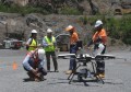
Toitū Te Whenua Land Information New Zealand (LINZ) has wrapped up the second season of data collection for its 3D Coastal Mapping (3DCM) program.
New data is now available to support coastal planning, hazard modelling and climate adaptation following fieldwork across nine regions between October 2025 and June 2026.
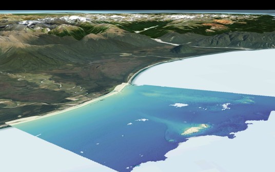
The program is building a detailed, nationally consistent picture of New Zealand’s coastline by collecting high-resolution elevation data from land to sea.
The data is freely released through the LINZ Data Service as it is processed, helping councils, iwi, scientists, infrastructure providers and communities make better decisions about coastal change and risk.
“New Zealand’s coasts face a range of risks including tsunami, storm surges, erosion, subsidence and earthquake related uplift, all of which are a risk to people, infrastructure, and coastal biodiversity,” said Stuart Caie, 3DCM Program Lead.
“This season reflects a significant effort to deliver high-quality coastal data that supports better decision-making.”
118 billion point cloud data points
LiDAR imagery capture has now been completed across Gisborne, Otago, Southland, Taranaki, Tasman, Waikato, the West Coast, Whanganui, and parts of Auckland.
In Otago, Discovery Marine Limited (DML) also completed targeted multibeam surveys in areas where turbid water limited LiDAR coverage. This work filled key gaps and revealed detailed geological features along the seafloor.
Data has been published for 23 areas, covering about 2,715 square kilometres across Otago, Tasman and Taranaki. A further 20 areas are scheduled for release over the next four months, including parts of Gisborne, Wellington and Auckland.
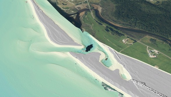

The program reached a milestone recently with the publication of classified point cloud data totalling 118 billion data points. These datasets provide a detailed 3D view of coastal environments and support work such as coastal hazard modelling, infrastructure planning and climate adaptation.
Data collection is set to resume in October, when private-sector mapping providers will return to complete the remaining areas.
‘Every dataset we publish gives decision-makers a clearer view of the coast and a stronger evidence base for the decisions ahead,’ said Caie.
Those interested can track progress and see when data becomes available for their area using the 3DCM progress tracker on the LINZ website.