


3D visualisation of the Gold Coast. Courtesy Euclideon.
There was a time not too long ago when, due to limited computing capabilities, efficient and speedy 3D visualisation of geospatial data would have seemed like a pipedream.
But modern information technology has turned that dream into a reality. Many companies and researchers across the globe are using 3D daily to solve real-world problems and boost commercial outcomes.
Australian company, Euclideon, is a local success story in this field. Founded in Brisbane in 2010, it has gone from enabling high-definition graphics for computer games to being able to provide detailed visualisation of the entire world on a laptop.
To find out more about how Euclideon sees 3D visualisation benefiting the geospatial industry, we spoke with the company’s CEO, Daniel Zhang.

Euclideon’s CEO, Daniel Zhang
POSITION: Tell us the Euclideon story.
DANIEL ZHANG: Euclideon was established in 2010 in Brisbane after Bruce Dell invented a special searching algorithm for use in three dimensions. We then created ‘unlimited detail’ technology that can load and render an unlimited amount of 3D data instantly with an ordinary computer. The technology was initially intended for trying to solve the limitation of data size in the gaming industry. As the algorithm is based on point cloud format rather than polygons, it became more valuable in the geospatial industry where laser scans are broadly used.
POSITION: How does high-speed streaming work?
DZ: Because the algorithm efficiently retrieves only one point for every screen pixel, it can display models of previously unimaginable sizes at interactive frame-rates without the need for a powerful graphics card. By removing the hardware bottleneck from the process of 3D visualisation, we’ve simultaneously removed any limitations on the amount of detail that a scene can contain.
Data capture can be in many formats — BIS, sonar, radar, GIS, GPS, LiDAR scanned point cloud, photogrammetry and others. Some formats are older and not used much anymore, while some like LiDAR from drones are the latest.
We’re working on merging more BIM data into the geospatial data for better planning and management purposes. And integrating the IoT sensor data, so we can help safety management, transportation management and mining.
POSITION: Can you give an example of its use?
DZ: Through partnerships like the Sustainable Minerals Institute (SMI) at the University of Queensland, we’re continuing to improve our technology by creating a seamless Digital Earth Visualisation of the state, which is part of an initiative to provide advanced 3D decision-making tools for the resources industry. Euclideon is working alongside SMI to solve some of the big issues around data interoperability and visualisation — key components to helping achieve a more sustainable and lower-impact minerals industry.
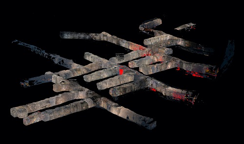
Visualisation of an underground mine. Courtesy Euclideon.
POSITION: How will your new Microsoft partnership change things?
DZ: We realised that industries using 3D data visualisation were facing a very big problem. Rapid growth was creating stress points in historic data management and storage solutions, which were not designed to handle the amounts of 3D geospatial data now being collected. We identified data availability as the main challenge, limiting the ability to visualise everything at once. This situation created a new opportunity, so we launched udCloud powered by Microsoft Azure. It’s still in its early days, having only just launched, however early customer acceptance is very promising.
POSITION: How can point cloud-streaming change the way clients work?
DZ: The cost of LiDAR 3D imagery has recently come down. This reduced price and the increased use of drones is attracting increasing numbers of users across many industries. The whole surveying industry is moving rapidly from 2D to 3D.
It is the next phase, overlaying geospatial 3D data with other scanned data to create 4D images, where new jobs and actions are being implemented… ones that could have been too difficult or dangerous to do before. Underground mine gas or movement sensors, when added to a 3D digital twin, can save lives, whereas previously staff may have had to go down and visually check or measure.
Another area is that of measuring change — how does today’s image of the same geography differ from the last seven days images? The dam now has more water, the fence has fallen down, the rail line is broken, the stockpile is larger. Decisions are being made at a desk using LiDAR 3D imagery and enhancement tools.
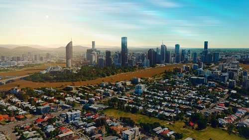
3D visualisation of Brisbane city. Courtesy Euclideon.
POSITION: Are people aware of the benefits that 3D visualisation can bring?
DZ: The geospatial industry is one of the fastest growing sectors globally. New technological advancements are delivering interactive insights that were not possible even a decade ago. Advanced geospatial analytics has become ingrained in countless sectors. The 4th Industrial Revolution — which includes things such as big data, AI, advanced robotics, automation etc — has geospatial at its core, as ‘location’ becomes the key.
We have been educating the market of the benefits and possibilities of digital twins and 3D visualisation. The COVID-19 pandemic has also driven increased use of digital twin technology, since traditional approaches have faced more challenges.
POSITION: What’s next for 3D visualisation, eg. quantum computing?
DZ: Firstly, anything reported historically in 2D can now be in 3D, and as humans naturally see everything in 3D this means information can be visually understood much more quickly. Therefore surveyors, engineers, architects, town planners, road and rail infrastructure, the military and miners have been the first users of 3D data visualisation. For instance, our defence customers have used us to build their command centre data platform so that the commander can share the same piece of data and its view with soldiers.
4D will be next, where we overlay another dimension of data on top of the geo-location information; for example the IoT sector will be a growing user of bespoke geospatial 4D solutions.
Yes, we may leverage quantum computing and other new technologies as and when the time is right. However, what is more important is the direction, value and use of geolocation in a multi-dimensional future… where overlaying of data onto geospatial information will drive demand, such as IoT, sensor integration with specific types of movement and the complexities of smart cities. At this stage we haven’t seen that quantum computing can be relied upon in the near future.
Today we have several PhDs in our R&D team pushing forwards with AI and machine learning enhancements. We are also leveraging partners like Riegl and Microsoft for future co-development, and our larger clients are today investing in developing bespoke competitive 3D custom solutions.
This article was first published in issue 115 of Position magazine.
Stay up to date by getting stories like this delivered to your inbox.
Sign up to receive our free weekly Spatial Source newsletter.


