

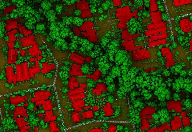
Image courtesy Aerometrex
LIDAR is the most precise way to measure tree canopies and gauge changes over time.
PARTNER FEATURE
The urban forest and tree canopy coverage is critical in mitigating the ongoing effects of climate change, providing thermal and shading benefits that increase safety and livability for residents. The urban environment is developing rapidly, replacing trees and green spaces with hard surfaces and creating urban heat islands.
Developing tree canopy policies supporting broader climate change mitigation strategies requires quality base data and ongoing measurement. Spatial tech company Aerometrex tested multiple methods for mass-measuring tree canopies and found how different solutions suit different objectives.
Aerial imagery and AI
High-resolution aerial imagery with artificial intelligence-based tree canopy coverage measurement is cost-effective and representative across large areas, making it suitable for macro insights. This method, however, is less accurate at a smaller scale because it lacks elevation information and has natural aspect distortions from the capture process.
Aerial imagery gives only a two-dimensional view and will not account for canopy height or vertical tree growth, as LIDAR does. All tree canopy coverage will be weighted equally in aerial imagery calculations, regardless of whether a tree gives on-ground thermal benefits. Further, aspect distortions measure trees on an angle or obscure them with buildings. A small area has potentially high variance from real-world canopy coverage, and each subsequent set of aerial imagery will vary from the previous. Aspect lean averages out across large areas but is more extreme at small scales.
Policy written from AI and aerial imagery-derived data must focus on large areas and offset the inherent variability at a small scale. It is, nonetheless, effective for measuring large areas, making it suitable for tree canopy coverage overview.
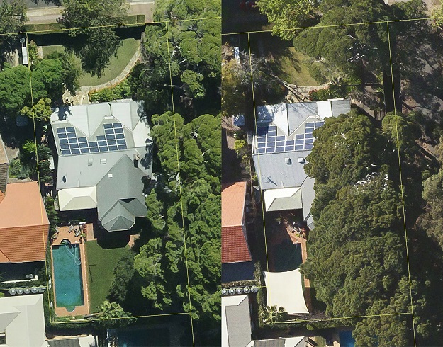
Varying aspect distortions show vastly different canopy coverage within this property’s boundary.
LIDAR
LIDAR is the most repeatably accurate way to measure 3D space at any scale and is the most precise way to measure tree canopies and gauge changes over time. It is the most robust data for policymakers and measure change over time.
LIDAR explicitly measures a tree’s location in a three-dimensional structure and is accurate enough to measure canopy change at individual tree levels. Councils can segment LIDAR data to track tree canopy within specific areas, down to the changes in individual trees, and better understand change distribution and land ownership status.
LIDAR data is flexible, with applications well beyond tree canopy measurement alone. Investing in a high-resolution LIDAR dataset benefits all spatial data users and provides ongoing benefits beyond tree canopy projects.
I-Tree Canopy
i-Tree Canopy is a free web-based measurement platform using statistical algorithms applied to Google Earth imagery. The platform’s simple and accessible web interface contributes significantly to increased awareness of protecting the urban forest. It has empowered environmental management experts to track tree canopy cover that otherwise may not access more complex methodologies.
i-Tree Canopy is effective for broad and general insights across large areas but lacks accuracy compared to aerial imagery and LIDAR due to its lower-resolution source data.
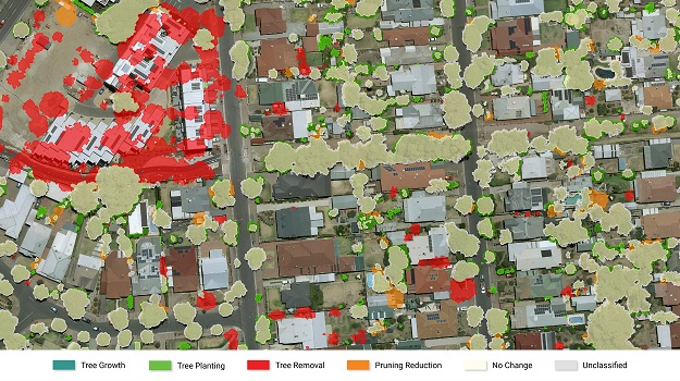
Aerometrex’s project with the City of Unley won the 2021 APSEA-SA Environmental & Sustainability Award.
The best data
Aerometrex determined that a mixture of LIDAR and aerial imagery provides the best overall dataset to quantify and track tree canopy coverage changes accurately.
The City of Unley in South Australia commissioned Aerometrex to measure changes in tree canopies across their jurisdiction. The base datasets were LIDAR captures in 2018 and 2021 with supplementary high-resolution MetroMap aerial imagery data segmenting the canopy change into existing tree growth, pruning existing trees, tree removal and tree planting.
The final report showed total canopy coverage change, land ownership distribution of the canopy loss, cause of canopy loss from tree removal or pruning, and how much existing or newly planted trees contributed to the overall canopy coverage change. The City of Unley has a high-accuracy dataset on which to base tree canopy policy and a proven method to measure canopy in future.
Measure your tree canopy coverage
Contact the MetroMap team to learn more about measuring canopy coverage — https://metromap.com.au/lidar/.
This article was first published in the Apr/May 2022 issue of Position magazine.
Stay up to date by getting stories like this delivered to your inbox.
Sign up to receive our free weekly Spatial Source newsletter.


