

Australian scientists are analysing the first images taken by CyanoSat, a hyperspectral imaging satellite payload designed and built by CSIRO in partnership with the University of Adelaide.
CyanoSat carries a special imaging system designed to spot dangerous cyanobacteria produced by algae along Australia’s coast and inland waterways.
It took just 18 months for the team to take CyanoSat from design to launch aboard a Skykraft satellite in June 2023.
The team had to work around problems caused by the COVID-19 pandemic.
“There were lots of doubts about whether we could get it done on time, and we had a lot of struggles with lockdowns and electronic parts shortages. There were times we couldn’t travel or even go to work in our own labs, but the passion of the team and the support of our partners was crucial,” said Dr Stephen Gensemer, the project leader.
Following launch, the payload has been put through its paces, with tests being conducted on its ability to capture short-burst images, along with on board data processing and on-orbit reprogramming.
“This data shows us that here in Australia we can design and build a sophisticated payload, custom-built for a specific application, integrate it into a satellite, and have it operating on orbit all within a very short period of time,” Dr Gensemer said.
“We’re thrilled to have helped make the CyanoSat test flight a success. The collaboration is a great example of how an Australian space company can support new research of national significance by piggybacking off our commercial Air Traffic Management constellation development,” added Dr Doug Griffin, Chief Engineer at Skykraft.
CyanoSat was conceived as a way to testbed water quality monitoring from low-Earth orbit, in parallel with development of CSIRO’s AquaWatch Mission. AquaWatch will comprises a system of technologies — including Earth observation satellites and ground-based water sensors — to monitor water quality with real-time data and predictive analysis.
Testing technology
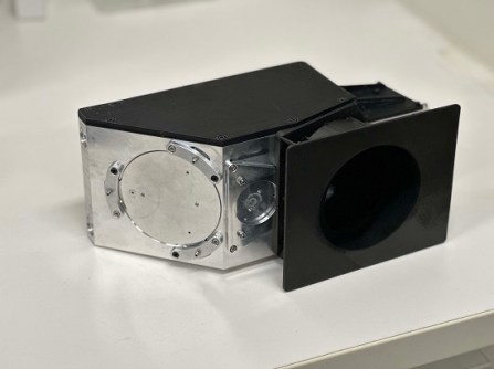
CyanoSat’s success is based upon a novel telescope, imaging and electronics package. The telescope uses a three-mirror, off-axis design to avoid astigmatism and improve image quality and optical throughput while enabling a broad range of wavelengths to be captured. It produces 50-metre ground resolution from an orbital altitude of around 600 kilometres.
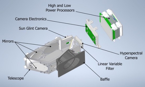
The imaging system has a linear-variable optical filter designed and manufactured by the CSIRO Space Optics team in conjunction with the Future Industries Institute at the University of South Australia. According to the CSIRO, the “transmissive optical filter has a resonant wavelength that varies linearly across one dimension. It is produced by precisely depositing a multilayer stack with a varying thickness, which can be tailored to capture any spectral range.” The filter is bonded directly to the camera sensor and produces data across more than 30 bands, from the visible to near-infrared.
The electronics package uses radiation-tolerant components and incorporates special radiation shielding materials developed by the CSIRO. To tackle the problem of sending copious amounts of data to the ground, the system has on-board algorithms that stores the data, pre-processes it to reduce its size, and prioritises downlink transmissions. The system can also be reprogrammed on-orbit.
CSIRO is working on a next-generation payload, CyanoSat 2.0, due for launch in 2024, which will apply lessons learned from CyanoSat. The new payload will feature a wider field of view and will be used to further test the ability of the imager to detect and monitor algal blooms from low-Earth orbit.


