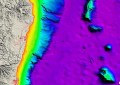
The gravity field of the Indian Ocean west of Australia, based on the new satellite-derived gravity model. The map reveals the detailed fabric of oceanic fracture zones, abyssal hill fabric, seamounts, submerged microcontinents and ancient extinct spreading ridges.
A new high-resolution marine gravity map that reveals tiny seafloor features has been created by an international scientific team using satellite radar measurements of the ocean surfaces.
University of Sydney geophysicist Professor Dietmar Müller is a member of the team whose research was published this week in the international journal Science.
The team combined new radar altimeter measurements from satellites CryoSat-2 and Jason-1 with existing data to construct a new global marine gravity model. The result is a model two times more accurate than previous models, and one which reveals thousands of previously unseen seamounts.
The new map also reveals an ancient, extinct mid-ocean ridge from the Jurassic Period in the Gulf of Mexico and a huge ancient rift scar in the South Atlantic Ocean formed by a deep-seated ‘hotspot’ leading to a cracking of the ocean floor.
Professor Müller says the disappearance of Malaysia Airlines flight MH370 earlier this year has heightened global awareness of the poor knowledge of our ocean depths.
“How much do we know about what’s actually down there, let alone about what’s underneath the seabed?” commented Prof. Müller. “We know much more about the topography of Mars than we know about Earth’s seafloor.”
“While thousands of metres of water obscure our view of an incredible array of geological features populating the seafloor, satellites enable radar beam ‘altimetry’ topographic mapping from space.
“They measure the humps on the sea surface caused by water being attracted by submarine mountains. Conversely, sea surface levels fall above deep valleys,” said Prof. Müller.
“The map offers an amazing glimpse of the fine-scale structure of deep abyssal seafloor, which is normally inaccessible, including thousands of previously uncharted seamounts.”
The new map also reveals previously unknown tectonic microplates in the Pacific Ocean, as well as detailed kinks in fracture zones, linear scars on the seafloor that trace out plate motion.
“These bends owe their existence to sudden re-organisations of the tectonic plates, giant shake-ups that can lead to catastrophic events including episodes of volcanism and climate change,” said Prof. Müller.
The unknown forces driving these changes are currently being explored by supercomputer simulations of the slow convective churning of the deep Earth’s mantle, where rocks flow like warm toffee.
The high-resolution digital maps also provide a basis for mapping rough seafloor patches, which affect deep ocean circulation, with potentially dramatic effects on global climate by influencing ocean mixing.
These sorts of discoveries allow us to better understand Earth’s tectonic engine and highlight the importance of satellite imaging as one of the primary tools for the investigation of remote ocean basins.
“One of the most important uses of this new marine gravity field will be to improve the estimates of seafloor depth in the 80 percent of the oceans without depth soundings. Even after 40 years of mapping by hundreds of ships one finds that more than 50 percent of the ocean floor is more than 10 kilometres away from a depth measurement. Between the soundings, the seafloor depth is estimated from marine gravity measurements from satellite altimetry,” said Prof. Müller.
You can read more about the newly discovered seamounts at the BBC.