


New research has found that many global sea-level assessments are way off, due to the use of geoid-based assumptions rather than actual land elevation data.
For many locations in the Northern Hemisphere, coastal sea-level height may have been underestimated by around 25cm.
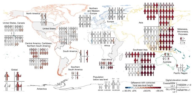
For the Global South, particularly Southeast Asia and the Pacific, that figure is closer to 1 metre.
Scientists Katharina Seeger and Philip Minderhoud, from Wageningen University in the Netherlands, conducted a meta-analysis of 385 studies published between 2009 and 2025.
They found that “more than 99% of the evaluated impact assessments handled sea-level and land elevation data inadequately, thereby misjudging sea level relative to coastal elevation”.
“Based on our literature evaluation, 90% of the hazard assessments assume coastal sea levels based on geoid models, rather than using actual sea-level measurements,” they say.
A need for re-evaluation
The geoid is a theoretical model of the shape of the Earth based on gravity measurements and the planet’s rotation, and is therefore a global approximation.
The geoid does not account for tides, currents, winds or precise local land elevations.
“The impacts of sea-level rise and other hazards on the coasts of the world are determined by coastal sea-level height and land elevation,” the scientists write in their paper.
“Correct integration of both aspects is fundamental for reliable sea-level rise and coastal hazard impact assessments, but is often not carefully considered or properly performed.”
“Our meta-analyses on global scale show that measured coastal sea level is higher than assumed in most hazard assessments (mean offsets [standard deviation] of 0.27 m [0.76 m] and 0.24 m [0.52 m] for two commonly-used geoids).
“Regionally, predominantly in the Global South, measured mean sea level can be more than 1 m above global geoids, with the largest differences in the Indo-Pacific.
They go on to say that “Compared with geoid-based assumptions of coastal sea level, the measured values suggest that with a hypothetical 1 m of relative sea-level rise, 31–37% more land and 48–68% more people (increasing estimates to 77–132 million) would fall below sea level”.
Making assumptions
Seeger and Minderhoud point out that most of the studies do not make measurement errors as such, but simply use a common, inadequate assumption of sea level based on the geoid.
“Assessing coastal exposure and vulnerability… requires the use of elevation information, commonly provided by digital elevation models (DEMs),” they write.
“Constituting the fundamental base of any such impact and exposure assessment, the quality (mainly vertical accuracy and spatial resolution) of the DEMs is fundamental to the accuracy and reliability of the derivatives and widely addressed in scientific literature…”
The authors say that while high-quality elevation information — such as that obtained via airborne LiDAR programs — is available for parts of the Global North, “the best available elevation data for the vast majority of the coastal areas worldwide is satellite-based”.
The problem is that spaceborne DEMs can have vertical errors of as much as several metres, or have sensing or interpolation artefacts, or simply be out of date. All of these factors can negatively affect coastal hazard assessments, especially for flat regions such as coastal plains and river deltas.
The use of DEMs for coastal hazard assessments requires “correctly combining coastal elevation with local sea-level height and the proper conversion to a common vertical reference frame,” the researchers say, adding that “… we found that these crucial steps were often not considered or performed incorrectly”.
“Rather than considering actual, local sea-level height, coastal sea level is most often assumed to equal (an often outdated) global geoid (or in some instances even ellipsoid), to which open-access global DEMs are typically referenced when provided.”
Better data needed
Seeger and Minderhoud conclude by speculating that these problems occur possibly because the complicated geodetic transformations required are left “in the hands of non-specialist end users unfamiliar to [sic] the required processing steps”.
“One solution to avoid future errors from omitted or wrongly performed datum conversion and sea-level referencing may lie in the hands of the data providers, which could provide readily combined products of digital terrain with sea level to facilitate proper end use…” they write.
Commenting on the research and its implications for the Pacific, Gabriel Mara, Pacific Adaptation and Loss and Damage Analyst with Climate Analytics, say that “This paper finds something quite concerning; many of the projections have underestimated both what we are currently measuring and what we are likely to experience in the future”.
“For Small Island Developing States (SIDS), that is far from a discrepancy. Because if the projections are conservative, then the policies, infrastructure standards and adaptation plans built on those projections are conservative also.”


