PARTNER FEATURE
The highly affordable Emlid Reach RS2+ multi-band RTK GNSS receiver is working wonders in Australia’s Top End.
Cross Solutions is a Northern Territory-based surveying consultancy that started life in Gove in 1992. It has since expanded to cover most of the NT as well as far north Queensland, and has offices in Katherine, Gove, Groote Eylandt and Cairns.
Jonathan Piper-Green, GIS & Innovation Manager, who has been with the company for 10 years, says that Cross Solutions has become a preferred supplier for a lot of things that involve remote work.
“We do bathymetry, lots of drone survey related activity, laser scanning and so on. We cover all the major sectors, so we have surveyors doing cadastral work, as well as people working on defence projects, gas projects, mining, civil, materials handling, engineering and the process industry,” he said.
Piper-Green says a challenge the company faces, unlike for the southern states, is that there isn’t a well-fleshed out CORS network, or even SmartNET or Trimble VRS. So they have to use base stations for a lot of GNSS-related activity.
For the majority of the company’s life, Cross Solutions has mainly used high-end gear from the big traditional surveying equipment manufacturers. “Part of the problem with using that gear is that, being such proprietary equipment, there is an integration friction that you might face with trying to do anything but work within their ecosystem,” says Piper-Green.
“But also there’s a price point. Whenever you’re looking to set up a system, you’re essentially going to require a base station to pair with that system and there’s quite a significant cost involved with going down the path of to pair up with those systems,” he said. “So we’ve been looking for a more cost-effective option.”
That’s why the company began using Emlid Reach units about four years ago. Piper-Green says they integrate well with other devices Cross Solutions uses.
“Particularly what we like about it is that they’re controlled through a phone app, so you don’t have to invest in additional field controllers or software, which lots of other receivers require,” he says. “You might have to buy a fully-fledged proprietary controller in order to work with those other devices, whereas with the Emlid you buy the receiver, you can use a smartphone which everyone has, and you’re good to go.”
“It definitely reduces the friction when pairing them up with other things; you don’t have to think about all that other complexity,” he adds. “It’s also quite easy to train people to use them, too. People are quite familiar with how to use their phone to connect things like Wi-Fi or Bluetooth as opposed to giving someone a new field controller.”
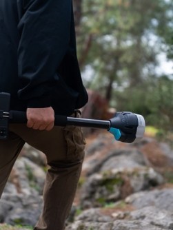
Piper-Green says the Reach RS2+ works in most senses like any other conventional survey GNSS receiver.
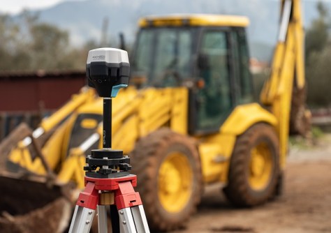
“We don’t typically use the RS2+ as a rover, meaning we’re not putting them on a pole and walking around and recording survey points with them — we typically find other uses for them because we rely on our conventional equipment for that sort of work. But they definitely have found a place in the business with some of those other applications, such as static logging or acting as a base station for a variety of different devices,” he said.
Simple software
Piper-Green says the Emlid software is very intuitive, making it easy to “understand how to get them logging what you want them to be logging and then get the data back off them so that you can post-process it”.
“Also, since we first started using Emlid, they’ve brought out a GUI-based software package that allows you to process static as well, which is quite handy. A lot of other companies charge for that sort of software, but Emlid doesn’t charge for firmware updates; they don’t charge for extra functionality.”
“And it’s pretty much all-inclusive. You don’t need a specialised controller, you don’t need extra software — you buy it and it’s ready to go.”
Another thing Piper-Green likes about Emlid is that the company has a long-running online forum where it takes feedback on the software and functionality, which often results in new features and bug fixes. “It’s really good to see that outreach back and forth between the customer base and the development team; the product gets better and better over time and if you have some receivers from two or three years ago, you’re not paying any extra to get those improvements,” says Piper-Green.
On the go
Cross Solutions is a heavy user of drones, and according to Piper-Green the Reach RS2+ has been easily incorporated into their aerial operations.
“We use them particularly with the DJI Phantom 4 RTK drones for the RTK corrections. DJI provides a similarly priced base station option, which works quite well because it’s integrated with the Phantom 4. The problem is it has limited functionality… you can’t use it with anything else other than that drone, more or less,” he says. Using the Reach RS2+ provides far more capability.
“If we go out and buy another drone, we tend to decide that we’re going to pair it up with the Emlid rather the drone manufacturer’s solution because of the benefits you get out of the Reach RS2+’s extra options. “When we’ve used the Reach, we’ve had a lot more consistent results than by using the drone base and you can then use the Reach for other tasks when it’s not needed as a drone base.”
The Reach RS2+ has also come into its own for some of Cross Solutions’ bathymetry tasks.
“We have a couple of radio-controlled boats and we’ve looked at real-time monitoring solutions where you have a GNSS receiver basically statically mounted on a pillar concreted into the ground, and you want to measure any movement that might occur. We’ve looked at integrating the Reach into that sort of set up, and in all those circumstances it’s performed exactly as intended,” he said.
“In fact, the integration with the Emlid gear has been generally the easiest part of the development projects that we’ve undertaken, because the system is so simple… there’s nothing that’s proprietary or hidden away or that you have to reverse engineer.”
Value for money
According to Piper-Green, a major advantage of the Reach RS2+ is its affordability, which puts less strain on a business’ cash flow and provides a cost-effective alternative for when the company has to do large static networks, particularly for cadastral work. “If you look at the cost of the Emlids, they definitely fit the bill for that sort of application really well.”
“Back in the day, there might have been a scenario which required five GNSS receivers that we just didn’t have as part of our inventory, so you’d have to start looking at things like renting the gear,” he said. “The consideration now is just, ‘Should we buy another Reach receiver?’”
“If you have to go out and rent the gear, maybe three or four receivers, you might not be able to get that in the timeframe you need it for. Whereas now you can have a bunch of spare receivers sitting on a shelf.”
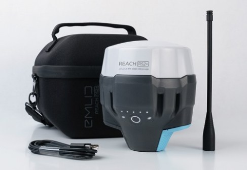
Emlid Reach RS2+
Type: RTK GNSS receiver
Multi-band: GPS/QZSS, GLONASS, BeiDou, Galileo
Fix: Survey accuracy up to 60 km in RTK, 100 km in PPK
Storage: 16 GB (160+ days logging at 1 Hz)
LTE: Built-in, with 2G/3G fallback
Battery: Up to 22 hours data logging on one charge; up to 16 hours as an LTE rover