

Clarence Valley Council has been recognised with a Granicus Digital Government Award for its live, interactive koala-sighting map.
The map, accessed through the Council’s Clarence Conversations portal, is based on the Granicus Engagement HQ platform.
Members of the public can log-in and report the locations of koala sightings within the Council’s area of responsibility.
“We’re so proud to receive this award,” Clarence Valley Council’s General Manager, Laura Black, said.
“It encourages people to get involved through citizen science and digital tools, helping collect valuable environmental information.”
Protection and conservation
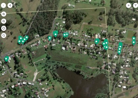
The project uses a two‑way digital system through Clarence Conversations and an interactive map, whereby residents can report koala sightings via the Koala Register.
Each sighting is automatically added to a live map showing where koalas are being seen.
“All reported sightings are collected and shared with BioNet, the NSW Government’s main database for plants and animals,” said Black.
“This information is then used to support biodiversity studies, environmental planning, threatened species protection, and wider conservation efforts across the state.”
Place-based solutions
“It’s not just about gaining scientific data — it’s also about community storytelling and participation, which is a key part of Clarence Conversations,” said Reece Luxton, Coordinator Natural Resource Management & Projects, Clarence Valley Council.
“It has brought the community together to protect a vital koala population and its habitat. This work connects to wider koala conservation efforts across NSW, where the species is listed as endangered.”
Luxton says that projects such as this one help build place-based solutions, rather than one-size-fits-all approaches.
“It has had an impact by increasing local awareness and participation in conservation, leading to better monitoring and protection of koalas in the region,” he said.
See also:


