
Held on Sunday, 9th February, 2020, the SSSI National Bushfire Recovery Map-a-thon was a way for the national and international community to work together to map a total of 2,793,879 hectares affected by recent Australian bushfires with the focus being on burnt infrastructure. Join us for this Webinar to hear more about the initiative.
Speakers:
Dr Lesley Arnold (SSSI National Board Director) will give an overview of the Map-a-thon initiative and discuss overall logistics of planning; industry, government and NGO engagement; the challenges and overall execution of the event.
Nathan Eaton, Executive Director, NGIS Australia will give an overview of the technical set-up of this mammoth Map-a-thon and highlight some of the challenges and triumphs experienced.
This is a free event open to those who participated in the Map-a-thon or are involved in the surveying and spatial community.
Details about how to join the Webinar will be emailed to you prior to the event.
To read more about the SSSI National Bushfire Recovery Map-a-thon see the news item here
The Advancing Earth Observation Forum 2021 is a new, completely online, single-day event, focused on high-value sessions that will give members of the EO community the opportunity to actively engage, contribute, learn and connect with others. This will be a chance for individuals, businesses and organisations to build professional expertise and contribute to Australia’s collective national capabilities.
The 2021 event will be followed by monthly webinars from September 2021 to June 2022 and an in-person and interactive Advancing Earth Observation Forum that will take place in Brisbane in August 2022.

Organised by OSGeo, this international annual gathering of location enthusiasts is the largest global gathering for geospatial software. Now in its 15th year, FOSS4G (ie. Free and Open Source Software for Geospatial) brings together developers, users, decision-makers and observers from a broad spectrum of organisations and fields of operation.
Through six days of workshops, presentations, discussions, and cooperation, FOSS4G participants create effective and relevant geospatial products, standards, and protocols. The 2021 event will be focused for the first time on South America and will be held with the close collaboration of the GeoLibres Association in Buenos Aires, Argentina.
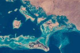
During GEO Week 2021, the Group on Earth Observations will present the multidisciplinary activities of the GEO Work Programme that address policy agendas involved in the UN Framework Convention on Climate Change (UNFCCC) COP26, the Convention on Biological Diversity (CBD) COP15, the UN Decade of Ocean Science for Sustainable Development and the UN Decade of Ecosystem Restoration.
The online event will include the GEO-17 plenary, plus anchor and side events. Time will be scheduled each day for virtual networking. On Monday, November 22, the 56th Executive Committee will be held as a closed meeting.
Of particular importance will be the anchor events: These are the main events designed by GEO week 2021 organisers to explain the multidisciplinary nature of GEO through the concept of nexus thinking. Working on multiple topics simultaneously is essential in today’s rapidly changing environmental and social conditions. For example, work in one area will have a knock-on effect or impact in another area, such as the water, energy and food nexus. These events are linked to the global policy agendas that underpin most of GEO’s work.
Image credit: NASA
Advancing Earth Observation Forum 2022 will be a face-to-face, fully interactive forum. It will host user, industry, government, research and technical focused plenaries and interactive panels, poster and workshop sessions to interest and engage end-users, industry, researchers, government, analysts, start-up companies, educators and students.

The 16th annual congress of the Open Source Geospatial Foundation, the non-profit organisation that supports and promotes the collaborative development of free and open source geographic technologies and open geospatial data, will be held in Florence, Italy, at the Palazzo dei Congressi, Palazzo degli Affari and the University of Florence.
FOSS4G (ie. Free and Open Source Software for Geospatial) brings together developers, users, decision-makers and observers from a broad spectrum of organisations and fields of operation.
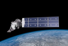
SmartSat partners, participants, students and staff are invited to come together to share their research outcomes and network with industry colleagues at the SmartSat CRC Conference 2023.
The SmartSat CRC is a consortium of universities and other research organisations, partnered with industry that has been funded by the Australian Government to develop know-how and technologies in advanced telecommunications and IoT connectivity, intelligent satellite systems and Earth observation next generation data services.
Landsat image courtesy NASA/GSFC

The Indo-Pacific Space & Earth Conference will delve into technologies that can be applied both on Earth and in space — from AI and robotics to remote operations. All industries from mining, oil and gas, agriculture, medicine and more can benefit from investing resources into these technologies.
Supported by key industry players and the government, the goal of the conference is to bring everyone together to discover new innovations and capabilities to create future opportunities.
Image credit: ©stock.adobe.com/au/MclittleStock

The annual Geo Connect Asia Show & Conferences offers a two day, in-person meeting place for ASEAN’s vibrant geospatial community. Bringing geospatial solutions to the heart of decision-making the event combines with technologies from the digital construction, drone and remote sensing markets.
Geo Connect Asia looks to host its ASEAN neighbours and build on a vibrant community as new technologies add new application tools to enable the Industry 4.0 Revolution. The emergence of AI, blockchain, IoT, robotics and UAVs create a new dynamic and platforms for a region well equipped to take on the challenges ahead.

The 4th International Symposium on Applied Geoinformatics (ISAG2024), which will take place at the Wroclaw University of Science and Technology, Wroclaw, Poland, on 9 and 10 May 2024. ISAG2024 is jointly organised by the Department of Geomatics Engineering, Yildiz Technical University, Istanbul, Türkiye, Wroclaw University of Science and Technology, Wroclaw, Poland and Technical University of Crete, Chania, Crete, Greece.
The aim of the 4th ISAG is to bring scientists, engineers and industry researchers together to exchange and share their experiences and research results and discuss the practical challenges encountered and the solutions adopted in geoinformatics.
Topics to be covered include recent advances in AI, satellite imagery, advanced remote sensing, photogrammetry, image processing, global navigation satellite systems, height systems, terrestrial laser scanning, GIS, smart cities and land management.


