During 2020 an expert group drafted the SPACE+SPATIAL Industry Growth Roadmap 2030 – a national snapshot for Australian professionals to better understand the bold new future that’s rapidly approaching and what it means for them, their careers, their organisations and all of Australia.
The National Steering Committee is seeking feedback on the Roadmap from spatial professionals of all levels across the country. There are a number of ways to get involved, one of which is to participate in this SSSI and SIBA|GITA SPACE+SPATIAL Roadmap Online Session.
You will hear about the key plans, activities and issues and have the opportunity to have a meaningful discussion with colleagues about your thoughts on the Roadmap Consultation Paper and the topic in general.

Organised by OSGeo, this international annual gathering of location enthusiasts is the largest global gathering for geospatial software. Now in its 15th year, FOSS4G (ie. Free and Open Source Software for Geospatial) brings together developers, users, decision-makers and observers from a broad spectrum of organisations and fields of operation.
Through six days of workshops, presentations, discussions, and cooperation, FOSS4G participants create effective and relevant geospatial products, standards, and protocols. The 2021 event will be focused for the first time on South America and will be held with the close collaboration of the GeoLibres Association in Buenos Aires, Argentina.

Hosted by 12d – the companies behind 12d Model and 12d Synergy – the highly anticipated 12d Tech Forum returns on 19 – 21 October 2021. The three-day online industry summit will connect over 2,000 surveying, engineering, and construction professionals to learn, innovate, and be inspired.
The 12d Tech Forum provides surveying and geospatial professionals with an excellent training opportunity to keep up to date with the latest innovations and advancements in the industry.
50+ Hours of Inspiring Industry Talks
The 12d Tech Forum will host over 50 hours of industry insights, case studies from cutting-edge Australian and New Zealand surveying projects, and actionable training content. Delivered by some of the greatest minds and speakers in the industry. Talks are tailored for surveyors, engineers, and directors, not just 12d operators.
Free Access to All Keynote Presentations
We’ve secured a huge line-up of 40+ industry speakers, including talks from Land Surveys, Fulton Hogan, GHD, SMEC, Piritahi, and many more.
A few keynote titles include:
- Pilbara Desert Collaboration: Land Surveys’ data management strategy collaborating across the Pilbara desert
- GDA2020 at Mackay City Council: Practical insights into successfully implementing GDA2020 through 12d Model
- Piritahi Case Study: 10,000 lot land development project to crush the Auckland housing crisis
- TfNSW Steering Group & Uniform Coding: Aligning managed utilities through a consistent framework for delivery
Best yet, all sessions will be recorded and available to watch on-demand for 12 months after the event.
Surveying and Geospatial Topics Include…
- BIM & Digital Engineering
- Land & Construction Surveying
- GDA2020, ADAC, A-SPEC
- Point Clouds
- Drone Surveying & Photogrammetry
- Mobile Mapping & GIS
- Digital Twins & Asset Management
- Data Management & Collaboration
Check Out the Preliminary Event Agenda
To see a comprehensive list of keynotes and topics that will be covered at the 12d Tech Forum 2021, check out our Preliminary Event Agenda here.
12d Training Breakout Streams
For more tailored training content focused on upskilling your use of 12d software, purchase a Training Pass (A$149 +GST). Here you will have access to an additional five technical streams covering topics on Design, Survey, Water, Data Management, and Training.
Accrue CPD Points
Every hour you watch of the 12d Tech Forum can earn you 1 CPD point for many industry institutions, such as SSI, Australian Consulting Surveyors, Engineers Australia, and many more.
Virtual Networking Sessions
Meet like-minded individuals and build lasting relationships with our virtual networking sessions. The online forum will be attended by thousands of surveying, mapping, and geospatial professionals from across Australia, New Zealand, and abroad.
Register for FREE Today
Join over 2,000 professionals and gain access to 50+ hours with 150+ in-depth talks, delivered by over 60 speakers. Register for your free Industry Pass today!
To learn more and register, visit 12dtechforum.com/

Join Bentley Systems at the launch of what it says is the industry’s most complete Survey and Site Design Solution ever offered to the ANZ market.
As technology advances and industry expectations increase, your software needs to keep pace with this ever-changing environment. In short, your software needs to deliver on today’s requirements and be ready for tomorrow’s challengers.
If you work in road design, site surveying, site development and related fields, this webinar is for you.
Throughout the launch, Bentley Systems will demonstrate traditional survey data capture capabilities, coupled with the latest mass data collection survey methods, including Total Station techniques, Point Cloud techniques and Digital Photogrammetry techniques.
Leveraging the above survey results, the launch will continue through a typical site design workflow, incorporating aspects such as:
- Terrain creation and analysis
- Urban road widening design
- Carpark and recreational area design
- Drainage and Utility design and analysis
- Plan production and digital model delivery
- Model visualisation
Air Inspect Australia will also be joining the webinar to share their insights and learnings of their project.
If you or your company perform any of the above-mentioned workflows, then this is one webinar you should not miss.

The 16th annual congress of the Open Source Geospatial Foundation, the non-profit organisation that supports and promotes the collaborative development of free and open source geographic technologies and open geospatial data, will be held in Florence, Italy, at the Palazzo dei Congressi, Palazzo degli Affari and the University of Florence.
FOSS4G (ie. Free and Open Source Software for Geospatial) brings together developers, users, decision-makers and observers from a broad spectrum of organisations and fields of operation.

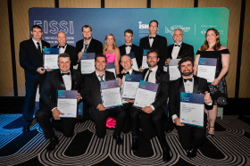
Each year representatives from the Association of Consulting Surveyors NSW and the Institution of Surveyors NSW come together to organise the NSW Excellence in Surveying and Spatial Information (EISSI) Awards.
The awards recognise the achievements of organisations and individuals from across the state who are engaged in the surveying and spatial information profession; celebrate excellence before an audience of industry peers; encourage activities that create a stronger, larger and more relevant industry; and embrace the achievements of the industry and its related industries and professions.


