The Australasian Hydrographic Society NZ Region, in conjunction with the Space & Spatial New Zealand Hydrography Stream, are holding a 1-day seminar on Friday, 8 July 2022 at the Miramar Golf Club, Wellington.
The seminar will align closely with the IHO’s World Hydrography Day theme “Hydrography – contributing to the United Nations Ocean Decade”.

Commercial UAV Expo, September 6-8 in Las Vegas is the premier event for the commercial drone industry focusing on the integration/operation of commercial UAS.
The event will feature exhibits and demonstrations by UAS solutions providers; keynotes, panel discussions, and presentations with interactive Q&A and chat; AI-powered networking; and more.
Industries covered include Construction; Drone Delivery; Energy & Utilities; Forestry & Agriculture; Infrastructure & Transportation; Mining & Aggregates; Public Safety & Emergency Services; Security; and Surveying & Mapping. It is presented by Commercial UAV News and organised by Diversified Communications.
Use code SAVE100 for a US$100 discount and/or FREE expo admission.
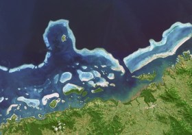
Hydrographers and all those with an interest in hydrography and related disciplines, are invited to attend a World Hydrography Day 2023 Seminar in Suva, Fiji, on 22 and 23 June.
The seminar will be held jointly by the Australasian Hydrographic Society and the Fiji Hydrographic Service. The venue will be the Moana Anglican Services and Teaching Centre at St John the Baptist Theological College.
The organisers are calling for potential sponsors and presenters to get in touch.
The theme for World Hydrography Day 2023 is ‘Hydrography: Contributing to the United Nations Ocean Decade’.
The seminar comes after a two-year pause due to the COVID pandemic and associated travel restrictions. It will provide an opportunity for professionals to network and share hydrospatial knowledge through presentations and discussion.
It is also intended that the presentations will highlight the empowerment of women within the hydrography field.
Registration is free but places are limited. Registrations must be secured by close of business, Tuesday, 20 June 2023.
The International Cartographic Association (ICA) invites you to share your research, practice and experiences in cartography and GIScience at the 31st International Cartographic Conference (ICC 2023), to be held from 13 to 18 August 2023 in Cape Town, South Africa.
The conference theme will be ‘Smart Cartography for Sustainable Development’.
Important dates:
- 5 December 2022 – Submission of full papers closes
- 12 December 2022 – Submission of abstracts closes
- February 2023 – Conference registration opens
- 28 February 2023 – Notification of acceptance
- 8 May 2023 – Submission of revised abstracts and papers
- 15 May 2023 – Early Bird registration closes
- 15 May 2023 – Registration deadline for presenters of abstracts, papers and posters

The Local Government Spatial Reference Group (LGSRG) will be holding a webinar on Monday, 4 September, to introduce a series of hands-on workshops it will be holding across Victoria during September 2023.
The webinar will cover the topic of Best Practice Geospatial Intelligence for Climate Impact, and will address important topics on climate impact, community safety and how geospatial intelligence can contribute to better outcomes for local governments.
The LGSRG was formed in 2003 to address the need for a sector wide group representing the strategic interests of the Victorian Local Government sector with respect to spatial information. The LGSRG has been active throughout the COVID pandemic to keep the local government geospatial community connected and engaged via the annual Spatial Capability Workshop series which have grown year on year, and is now diversifying with a quarterly Spatial Hour webinar to share stories of success within the local government geospatial sector.
Image credit: ©stock.adobe.com/au/yutthana

The Remote Hydrography conference and exhibition brings together manufacturers, operators, regulators, and research and development leaders from both industry and academia, within the field of remote surveying and uncrewed survey operations.
Remote Hydrography 2024 provides an opportunity to share experience gained in the development and application of autonomous and uncrewed platforms (surface, underwater, aerial and space-based) and the associated command and support services.
These and enabling technologies like machine learning and artificial intelligence will revolutionise workflows for hydrographic data collection, processing, analysis and presentation.
The Wavelength meeting was launched in 2013 for PhD students and early career researchers, addressing the demand for representation of new professionals as well as students from RSPSoc — the UK society for remote sensing and photogrammetry science.
Every year, Wavelength gathers participants from student and early career levels, as well as senior members and individuals within academia and business. The conference offers a setting to present student and EC work and meet new, like-minded contacts.
The 2024 conference will be run in a hybrid format, to accommodate those who can and those who cannot travel to Worcester.

The 2024 edition of the International Conference on Geographical Information Systems Theory, Applications and Management (GISTAM 2024) aims to create a meeting point of researchers and practitioners that address new challenges in geo-spatial data sensing, observation, representation, processing, visualization, sharing and managing, in all aspects concerning both ICT as well as management information systems and knowledge-based systems.
The conference welcomes original papers of either practical or theoretical nature, presenting research or applications, of specialised or interdisciplinary nature, addressing any aspect of geographic information systems and technologies, such as:
- Data acquisition and processing
- Remote sensing
- Interaction with spatial-temporal information
- Spatial data mining
- Managing spatial data
- Modelling, representation and visualisation
- GIS and climate change
- Domain applications

The 4th International Symposium on Applied Geoinformatics (ISAG2024), which will take place at the Wroclaw University of Science and Technology, Wroclaw, Poland, on 9 and 10 May 2024. ISAG2024 is jointly organised by the Department of Geomatics Engineering, Yildiz Technical University, Istanbul, Türkiye, Wroclaw University of Science and Technology, Wroclaw, Poland and Technical University of Crete, Chania, Crete, Greece.
The aim of the 4th ISAG is to bring scientists, engineers and industry researchers together to exchange and share their experiences and research results and discuss the practical challenges encountered and the solutions adopted in geoinformatics.
Topics to be covered include recent advances in AI, satellite imagery, advanced remote sensing, photogrammetry, image processing, global navigation satellite systems, height systems, terrestrial laser scanning, GIS, smart cities and land management.

The ISPRS Technical Commission II ‘Photogrammetry’ focuses, at various scales, on geometric, radiometric and multi-temporal aspects of the image- and range-based 3D surveying, mapping and modelling in the age of AI and mixed reality.
The organisers of the June 2024 Symposium welcome researchers, practitioners and companies involved in photogrammetry and computer vision to present and discuss their results with a broader audience. The Symposium will feature four days of plenary and keynote talks, along with parallel sessions of oral and poster presentations from academia and industry.
The symposium’s theme is ‘The Role of Photogrammetry for a Sustainable World,’ emphasising machine learning and mixed reality. The event is being organised in collaboration with ASPRS (American Society of Photogrammetry and Remote Sensing) and SGPF (Swiss Society of Photogrammetry and Remote Sensing).
Image credit: ©stock.adobe.com/au/Lifes_Sunday


