
Organised by OSGeo, this international annual gathering of location enthusiasts is the largest global gathering for geospatial software. Now in its 15th year, FOSS4G (ie. Free and Open Source Software for Geospatial) brings together developers, users, decision-makers and observers from a broad spectrum of organisations and fields of operation.
Through six days of workshops, presentations, discussions, and cooperation, FOSS4G participants create effective and relevant geospatial products, standards, and protocols. The 2021 event will be focused for the first time on South America and will be held with the close collaboration of the GeoLibres Association in Buenos Aires, Argentina.

Survey and Spatial NZ’s 2022 conference will be held from 1 to 3 August at the Novotel Lakeside, Rotorua. The conference is the biggest continuing professional development event of the year for NZ surveying and spatial professionals. It invites sharing of knowledge amongst peers, bringing together networking opportunities for all delegates and is an essential event for professional development and connectivity within the sector.
The choice of Rotorua as the location is apt, given the conference theme of ‘Turning up the Heat’. The organisers aim to stimulate discussion regarding challenges in regional areas, which include climate change and developments outside of Auckland.

The 16th annual congress of the Open Source Geospatial Foundation, the non-profit organisation that supports and promotes the collaborative development of free and open source geographic technologies and open geospatial data, will be held in Florence, Italy, at the Palazzo dei Congressi, Palazzo degli Affari and the University of Florence.
FOSS4G (ie. Free and Open Source Software for Geospatial) brings together developers, users, decision-makers and observers from a broad spectrum of organisations and fields of operation.

The World of Drones and Robotics Congress New Zealand (WoDaRC NZ) is shaping up as an unmissable event for anyone involved in robotics, drones, AI, AgTech and data-led innovation. WoDaRC is business-led, technology based and will create opportunities for collaboration and growth across the technology ecosystem.
Topics to be covered include:
- Regional capability and strategy
- Humanitarian engineering and disaster response
- Environmental science and agricultural technology
- The new frontiers: oceans, mountains, and space
- Movies, media, community, and social empowerment
- Education

Planning is underway for the S+SNZ 2023 Annual Conference which will be held at Otago University in Dunedin from 30 August through to 1 September 2023.
The S+SNZ conference is the biggest continuing professional development event of the year for NZ surveying and spatial professionals. It invites sharing of knowledge amongst peers, bringing together networking opportunities for all delegates and is an essential event for professional development and connectivity within the sector.

The Local Government Spatial Reference Group (LGSRG) will be holding a webinar on Monday, 4 September, to introduce a series of hands-on workshops it will be holding across Victoria during September 2023.
The webinar will cover the topic of Best Practice Geospatial Intelligence for Climate Impact, and will address important topics on climate impact, community safety and how geospatial intelligence can contribute to better outcomes for local governments.
The LGSRG was formed in 2003 to address the need for a sector wide group representing the strategic interests of the Victorian Local Government sector with respect to spatial information. The LGSRG has been active throughout the COVID pandemic to keep the local government geospatial community connected and engaged via the annual Spatial Capability Workshop series which have grown year on year, and is now diversifying with a quarterly Spatial Hour webinar to share stories of success within the local government geospatial sector.
Image credit: ©stock.adobe.com/au/yutthana
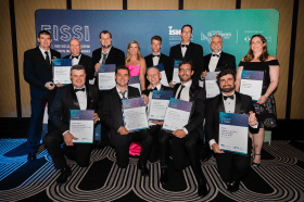
Each year representatives from the Association of Consulting Surveyors NSW and the Institution of Surveyors NSW come together to organise the NSW Excellence in Surveying and Spatial Information (EISSI) Awards.
The awards recognise the achievements of organisations and individuals from across the state who are engaged in the surveying and spatial information profession; celebrate excellence before an audience of industry peers; encourage activities that create a stronger, larger and more relevant industry; and embrace the achievements of the industry and its related industries and professions.
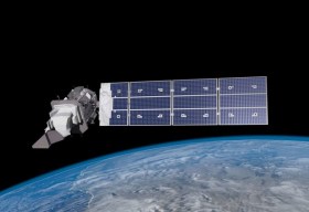
SmartSat partners, participants, students and staff are invited to come together to share their research outcomes and network with industry colleagues at the SmartSat CRC Conference 2023.
The SmartSat CRC is a consortium of universities and other research organisations, partnered with industry that has been funded by the Australian Government to develop know-how and technologies in advanced telecommunications and IoT connectivity, intelligent satellite systems and Earth observation next generation data services.
Landsat image courtesy NASA/GSFC

The New Zealand: Digital Twin 2024 Summit will explore the roadmap of digital twin systems and their impact on each stage of a project, and explore the core values, challenges and opportunities unique to the priorities of New Zealand and how digital twins can deliver them.
The event will feature real stories of success and failure, research insights, and focus not just on what has already happened but also on the potential of digital twins and where key opportunities for timely innovation appear to be.
Delegates will hear from technical experts, industry leaders and researchers in an experience designed to support the development of a dynamic and scalable digital twin ecosystem in New Zealand.
The International Federation of Surveyors (FIG) Working Week 2024 will be held in Accra, Ghana, from 19 to 24 May. The event is being held in cooperation with the two national associations: the Licensed Surveyors Association of Ghana (LiSAG) and the Ghana Institution of Surveyors (GhIS).
The event will comprise the following:
- Conference: 20-22 May
- FIG General Assembly: 19 and 23 May
- Pre- and post-events: 18-19 and 23 May
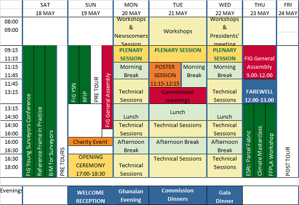
The FIG Working Week will be a week-long celebration of innovation and collaboration that unites the global community of surveying and spatial professionals, providing an opportunity to bridge the gap between science and the policymakers and stakeholders who drive real-world change.
The event will provide attendees the opportunity to:
- Immerse themselves at the forefront of geospatial technology and sustainable resource management.
- Elevate their expertise through hands-on workshops, interactive sessions, and thought-provoking discussions.
- Connect with like-minded professionals, experts and decision-makers from around the world.
The FIG Working Week 2024 is expected to attract more than 1500 attendees from around 80 countries, to participate in 70-plus presentation sessions and networking opportunities, and to experience a comprehensive trade exhibition.


