Eugene Lamnek created GeoIT Solutions in 2002, and has been developing ArcGIS customizations, add-ins and applications ever since. In this time Eugene has developed numerous bushfire applications for the CFS and the CFA as well as water and wastewater modelling software, asset management applications and interfaces, and open source applications for numerous clients including SA Water, Santos and DEW.
The Treatment Reporting System (TRS) currently in pilot phase, will allow organisations to store and manage their bushfire mitigation tasks, as well as measuring these tasks against the requirements of the Bushfire Management Area Plans (BMAPs). The system will allow users to store bushfire mitigation tasks, their spatial extent, values of work, time of work and completion status. Tasks are mapped and measured against required actions, defined by within the CFS BMAPs. The TRS will provide an effective mechanism for reporting the adequacy of on ground mitigation work (potentially at a State-wide level) by measuring mitigation work against well-defined mitigation targets. Users of the system will include local government, state government, private organisations and potentially even individual landholders.
Venue
Zoom Webinars
Cost
SSSI Members $30 | Non-Members $45 | SSSI YPs $20 | SSSI Student Members FREE
Contact
SSSI South Australia | rom.sa@sssi.org.au | 08 8212 0359

At 1Spatial we use validation, integration, automation and our rules-based approach to build strong data infrastructures, leading to better outcomes and making your data smarter.
Have you thought about how you will transform your data to GDA2020?
During this session, we will help you understand the requirements needed for GDA2020 and the best way to migrate your data to this new datum!
Join our team for a free webinar on Friday 27th November and hear how we can help you migrate your data to GDA2020.
Agenda
- Recognising your data and understanding the effect this will have on your data
- Authoritative data sets that already exist
- GA & ICSM slides defining the height datum + case studies of support issues
- Transformations with FME
- Ensuring your organisation has a plan for the transformation
- How we can help you implement the move
In the meantime, if you have any technical questions, or you’d just like a quotation on one of our products, some training or a dedicated consultancy session from one of our specialised consultants, just send us some details to sales.australia@1spatial.com and we’ll be sure to get back to you.
Did you know Australia is located on one of the Earth’s most rapidly moving tectonic plates? Resulting in Australia moving seven centimetres north-east per year!
Australian Government departments and private sector organisations are now contemplating their game plan for the migration of GDA94 to GDA2020. This data implementation is important for organisations that want to take advantage of having sub-decimetre coordinate accuracy when capturing high accuracy data.

Here at 1Spatial, we continue to work with customers across a range of diverse sectors delivering exciting and challenging projects that deliver new tools and platforms for managing their data. We have worked on projects with different customers to manage and track the transition to GDA2020- enabling users to migrate their data to the new datum.
During the session, we will hear from the latest case studies to help you understand the requirements needed to replace GDA94 with the new GDA2020.
Agenda:
- Opening intro – Andrej Mocicka
- Case Study – Whittlesea Council
- Case Study – Bayside Council
- Open Q & A with guest presenter Richard Stanaway from Quick Close
Join our webinar to learn how these organisations migrate their data to this new datum!
In the meantime, if you have any technical questions you would like answered during our session, send us an email sales.australia@1spatial.com and we’ll be sure to cover it.

The Advancing Earth Observation Forum 2021 is a new, completely online, single-day event, focused on high-value sessions that will give members of the EO community the opportunity to actively engage, contribute, learn and connect with others. This will be a chance for individuals, businesses and organisations to build professional expertise and contribute to Australia’s collective national capabilities.
The 2021 event will be followed by monthly webinars from September 2021 to June 2022 and an in-person and interactive Advancing Earth Observation Forum that will take place in Brisbane in August 2022.

This event defines and showcases the global commercial UAV industry, with a special focus on solutions in the Americas region and a glimpse into the world of urban air mobility. It showed consistent growth for 5 straight years, with 3,100+ live attendees in 2019 – up 32% – and a record 200 exhibiting companies.
It moves to much larger space right on the Las Vegas Strip for 2021 and adds a collocated Urban Air Mobility Summit produced by RAI Amsterdam. Strictly commercial by choice, it draws the power buyers and global influencers and sets the pace for the industry, with innovative formats, cutting-edge content, and unmatched excitement on the expo floor.
It is a must-attend event and will convene delegates and exhibitors from 6 continents. www.expouav.com Commercial UAV Expo Americas is produced by Diversified Communications’ technology portfolio which also includes Commercial UAV Expo Europe; Commercial UAV News; Geo Week comprised of the International Lidar Mapping Forum, SPAR 3D Expo & Conference, AEC Next Technology Expo & Conference; Geo Week ENewsletter, SPAR 3D ENewsletter, AEC ENewsletter.
For more information about exhibiting at Commercial UAV Expo, visit www.expouav.com/exhibition/ or contact Katherine Dow, Sales Manager, at kdow@divcom.com or +1.207-842-5497. For attending information, visit www.expouav.com or email info@expouav.com.

During GEO Week 2021, the Group on Earth Observations will present the multidisciplinary activities of the GEO Work Programme that address policy agendas involved in the UN Framework Convention on Climate Change (UNFCCC) COP26, the Convention on Biological Diversity (CBD) COP15, the UN Decade of Ocean Science for Sustainable Development and the UN Decade of Ecosystem Restoration.
The online event will include the GEO-17 plenary, plus anchor and side events. Time will be scheduled each day for virtual networking. On Monday, November 22, the 56th Executive Committee will be held as a closed meeting.
Of particular importance will be the anchor events: These are the main events designed by GEO week 2021 organisers to explain the multidisciplinary nature of GEO through the concept of nexus thinking. Working on multiple topics simultaneously is essential in today’s rapidly changing environmental and social conditions. For example, work in one area will have a knock-on effect or impact in another area, such as the water, energy and food nexus. These events are linked to the global policy agendas that underpin most of GEO’s work.
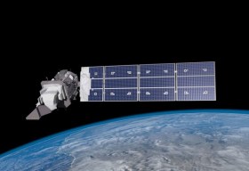
Image credit: NASA

Advancing Earth Observation Forum 2022 will be a face-to-face, fully interactive forum. It will host user, industry, government, research and technical focused plenaries and interactive panels, poster and workshop sessions to interest and engage end-users, industry, researchers, government, analysts, start-up companies, educators and students.

INTERGEO returns for 2023 with the motto, ‘Inspiration for a smarter world,’ with the event this year also incorporating the German Cartography Congress.
The conference and exhibition will cover the topics of geoinformation, geodesy, land management, Earth observation, urban planning, disaster prevention, environmental protection and energy efficiency, while tackling challenges such as the climate crisis, urbanisation and securing resources.
This year, there will be a special emphasis on drone technologies and BIM.

SmartSat partners, participants, students and staff are invited to come together to share their research outcomes and network with industry colleagues at the SmartSat CRC Conference 2023.
The SmartSat CRC is a consortium of universities and other research organisations, partnered with industry that has been funded by the Australian Government to develop know-how and technologies in advanced telecommunications and IoT connectivity, intelligent satellite systems and Earth observation next generation data services.
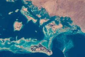
Landsat image courtesy NASA/GSFC

The Indo-Pacific Space & Earth Conference will delve into technologies that can be applied both on Earth and in space — from AI and robotics to remote operations. All industries from mining, oil and gas, agriculture, medicine and more can benefit from investing resources into these technologies.
Supported by key industry players and the government, the goal of the conference is to bring everyone together to discover new innovations and capabilities to create future opportunities.
Image credit: ©stock.adobe.com/au/MclittleStock


