
A panel of data and industry experts will examine changes to IP and copyright and the disruption of current business models that current and future technologies are creating, with an open discussion about governance considerations that may affect surveying businesses now and in the coming years. This will be an insightful, interesting and challenging discussion around how technology and big data are redefining business opportunities.
The speakers will be:
- Professor Kevin McDougall, Head of School, Civil Engineering and Surveying University of Queensland
- Rachel Sciascia, Partner, Gadens
- Nicole Stephensen, Principal Consultant, Ground Up Consulting Pty Ltd
- Adam Beck , Executive Director, Smart Cities Council Australia New Zealand Secretariat, Centre for Data Leadership
Image credit: ©stock.adobe.com/au/boreala

The presenters for this topical webinar will be Dr Craig Roberts, Senior Lecturer in Surveying/GPS/Geodesy at UNSW and Wayne Patterson Director, Spatial Operations at the NSW Department of Customer Service.
Roberts will give a short update on the revision of the Australian Standard, AS_5488 Classification of subsurface utility information in the context of datum modernisation, low-cost multi-GNSS and recent advances in positioning infrastructure in Australia.
Data storage, data distribution and security are identified as challenges suggesting a reimagined data governance will be needed. Could a spatial digital twin assist? What is a spatial digital twin? Is it a BIM? Where does it come from? What is an open data policy? Who can use it? Can I use it? Which datum? How accurate is the data?
Rather than just another PowerPoint webinar, Roberts will interview Patterson in a free-flowing format. Attendees will be invited to ask their own questions live in the chat as the conversation evolves.
This webinar is targeted at surveyors, geospatial users, students and the wider spatial community.

The ROTORTECH 2022 Helicopter and Unmanned Flight Exposition is the premier industry event for the Helicopter/Rotary Wing and RPAS/UAV/eVTOL community in Australia, New Zealand and the Indo-Asia-Pacific region.
The event provides a vital interface between industry, regulators and government, including:
- Operations and safety presentations
- Industry conferences
- Industry exposition showcasing the products and services of helicopter and unmanned flight related companies
ROTORTECH 2022 will host conferences by the Australian Helicopter Industry Association (AHIA) and Australian Association for Uncrewed Systems (AAUS) and feature presentations by key rotary and unmanned systems industry experts from Australia and the Indo-Asia-Pacific region.

The 2022 SSSI Victorian Surveying & Spatial Summit and APSEA-V Dinner will take place on Thursday, 27 October 2022. It will be an opportunity for all Victorian surveying and spatial professionals to come together to learn, share and connect.
The event will feature an array of speakers, along with plenty of networking opportunities and the chance to see the latest products and services from local suppliers.
Image credit: ©stock.adobe.com/au/Wirestock

The 2023 Victorian Geospatial Conference & Awards Dinner be an opportunity for Victorian professionals of all geospatial disciplines to come together to learn, connect and share, and also celebrate local excellence with the awards dinner in the evening.
This year’s program will feature three concurrent streams covering GIS, data, cadastral surveying, digital twins, remote sensing and more.
The Victorian Geospatial Excellence Awards dinner will take place from 6.00pm, immediately following the conference.
Image credit: ©stock.adobe.com/au/ink drop
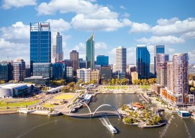
The Geospatial Council of Australia’s Western Australia Digital Twin Summit will be held on 15 November 2023.
The event will focus on Spatial Digital Twins, and attendees will hear the latest developments in this rapidly developing space from government, academia and private industry presenters.
The WA Asia-Pacific Spatial Excellence Awards dinner will also be held in conjunction with the conference, celebrating the outstanding work being undertaken across the region.
Image credit: ©stock.adobe.com/au/anekoho

The not-to-be-missed Geospatial Council of Australia (GCA) WA Digital Twin Symposium will be held on 14 March in Perth, giving geospatial professionals a chance to learn about the latest developments in this important field.
- Members: $220 (incl. GST)
- Non-members: $330 (incl. GST)
- Student members: $95 (incl. GST)
Registrations will close on Wednesday 6 March.


