Cadastral updates for NSW rural towns

By on 31 July, 2024
Upgrades to the NSW Spatial Cadastre in the town of Albert. White lines indicate the cadastral boundaries before the upgrade; yellow lines are post-upgrade. Image courtesy DCS Spatial Services.

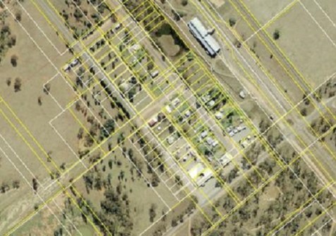
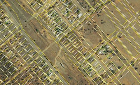
NSW’s DCS Spatial Services has completed updates of the spatial cadastre for the local government areas of Albert and Girilambone, two small towns in Western NSW.

The upgrades address concerns that had been raised by residents about inaccuracies in the data.

According to DCS Spatial Services, the upgrades have not only improved the accuracy of property boundaries but also took into account the specific needs of each community.

For Albert, a little over 500 parcels were positionally improved, with the average shift being 65 metres. The magnitude of the shifts arose partly from the original digitisation process, during which maps of varying scales were combined and hand digitised. Albert just happens to be on the boundary of two 1:50,000 map sheets, meaning that an inaccuracy as small 1mm on paper could result in a displacement of 50 metres.

In Girilambone, the accuracy of property boundaries for more than 500 parcels was enhanced, resulting in shifts of over 20 metres.

Upgrades to the NSW Spatial Cadastre in the town of Girilambone. White lines indicate the cadastral boundaries before the upgrade; yellow lines are post-upgrade. Image courtesy DCS Spatial Services.

DCS Spatial Services says its ongoing cadastral update program has so far positionally improved more than 1.3 million parcels across NSW, resulting in a better visual representation of property lines for residents and boosting accuracy within the NSW Spatial Cadastre.

You may also like to read:


, ,


Newsletter

Sign up now to stay up to date about all the news from Spatial Source. You will get a newsletter every week with the latest news.

Q&A with Zaffar Sadiq Mohamed-Ghouse
Combatting climate change, saving lives and building better ...
Satellite imagery helps coastal data collection
A new study highlights the accuracy of satellite-derived bat...
Geospatial in School Awards recipients announced
Two outstanding teachers and a high school student have been...
The geospatial reality capture revolution
Aptella’s solutions are transforming spatial data and revo...
Evolution in survey: XGRIDS and Gaussian splats
Using 3DGS and SLAM technology, XGRIDS bridges the gap betwe...
Emlid joins Esri’s global Partner Network
The move will enable Esri ArcGIS users to take advantage of ...