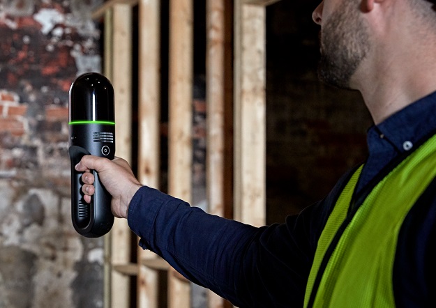
The Leica Geosystems BLK2GO handheld imaging laser scanner weighs just 775 grams, including the internal rechargeable battery.
C.R. Kennedy’s Western Australia team recently undertook a client site walk in conjunction with local surveying company, Links Surveying, who needed to capture an existing semi-occupied office complex and create leased floorplans.
It was decided that the Leica Geosystems BLK2GO handheld imaging laser scanner was the ideal product for the job, as it would provide the best and most time-effective solution for the task.
The BLK2GO recreates spaces in 3D by capturing images and dimensionally accurate 3D point clouds in real-time and uses SLAM (Simultaneous Localisation and Mapping) technology to record the user’s trajectory through space. The LIDAR data is combined with the imagery automatically to produce a colourised point cloud.
The device can scan over and under objects, through rooms and doorways, around corners, and up and down stairwells. The SLAM spatial awareness technology enables the BLK2GO to always know where it is and where it has been.
According to Leica Geosystems, the BLK2GO is the smallest dual-axis LiDAR available with what is claimed to be best-in-class accuracy. The unit is enclosed in a fully protected and encapsulated dome that scans up to 420,000 points per second. Both axes continually spin while scanning.
There’s no need for a tripod, and data is collected on board. The vision system is a 12-megapixel camera for high-contrast imagery plus three panoramic cameras for visual navigation via SLAM, point cloud colourisation and capture of panoramic imagery. The handle contains the WLAN connectivity electronics, a rechargeable battery capable of 45 minutes of continuous scanning, data storage for six hours of scans, and a USB-C port for fast data transfer and edge computing. A light guide that encircles the BLK2GO provides user guidance while scanning and communicates the device status and data quality. All up, the unit weighs in at just 775 grams.
The BLK2GO’s GrandSLAM technology combines the high-speed, dual-axis LiDAR, multi-camera vision system and an inertial measurement unit to make the unit self-navigating.
Walk and scan
For a job of this kind, a surveying company traditionally would use a Leica Disto to measure the overall room sizes before later processing these readings through its chosen CAD software. Doing it that way using a Disto or total station could have taken two to three days just to work through the building and capture only the room dimensions one by one… let alone the further work that would have had to be done to manually interpreted the data into the CAD software.
With the BLK2GO, that kind of workflow is a thing of the past.
The C.R. Kennedy team met up with Links Surveying on site and, before getting into the scanning, discussed the best way of tackling the job. Once ready to go, the team spent a total of just three hours at the site with a total of 106.97 minutes’ worth of scanning time split across 30 different walks.
Each tenancy was split into various scans depending upon its layout, with walks conducted through the common area of the building to enable the Leica Cyclone Register360 software to link the scans together with sufficient overlap. Some of these walks even took place through active tenancies with an abundance of moving people — this did not cause any issues and did not affect the finished point cloud or increase the time taken to scan.
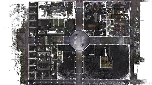
Overhead view of the scanned building’s ground floor point cloud data, via Register360.
The next stage was to process the data through Register360 back in the office. This involved importing 70 GB of data, reviewing the individual scans, cleaning up any troublesome point cloud noise and linking the 30 different walks across the two floors and the exterior of the building. This took around four hours, most of which was spent on the import phase.
Once the team was happy with the data and had performed the QA checks on the scan bundle, it was time to export the data out to an .lgs file for linking into CAD software through Leica CloudWorx. In this case, the team decided to model out the floor plans using Autodesk’s Revit and Leica CloudWorx for Revit. It took less than two days to model the site (windows, floors, doors and walls) using the point cloud data and produce leased area floor plans and room schedules.
It’s not an exaggeration to say that, from start to finish, a completed product can be generated within three days for a job such as this, all thanks to the capabilities of the BLK2GO.
Scanning a building with the BLK2GO
Time at Site: 3 hours (2 hours spent scanning)
Site type: Two floors of semi-occupied office space
Site area: 5,026m²
Raw data size: 30 walks totalling 70 GB
Processed data size: 5.17 GB .lgs file / 608 MB .rcp file
Processing time: 4 hours (using Register360)
Modelling time: 2 days (using Revit and CloudWorx)
Information provided by C.R. Kennedy and Company.