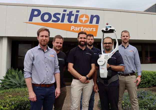
Left to right: Geoff Preece, Position Partners’ Market Development Manager Scanning; Claudio D’Anna, NavVis Technical Account Manager APJ Market; Liam Thierens, Bennett and Bennett Site Map Capability Manager; Michael Dutch, NavVis Senior Technical Account Manager; Nima Karkhaneh, Bennett and Bennett Site Map Technical Lead; and Patrick Hughes, Position Partners’ Customer Success Manager Scanning.
Bennett and Bennett has provided land surveying, town planning and spatial services throughout Southeast Queensland for more than 50 years. With more than 100 employees, the company is well resourced for small and large-scale projects and has adapted its business over time to embrace the latest technology and surveying methods.
To complement the firm’s terrestrial mapping capabilities, Bennett and Bennett has recently taken delivery of a NavVis VLX wearable mobile mapping platform, sold and supported in Australia and New Zealand by Position Partners. Powered by SLAM technology, the VLX delivers survey-grade point clouds at speed, capturing data as the user walks around the area to be mapped.
Site Map Capability Manager, Liam Thierens, said the NavVis VLX will be used predominantly for Scan to BIM applications. “The VLX fills a gap in our scanning artillery and provides us the ability to quickly capture an environment from all angles without the shadows you find with static laser scanners,” he said.
“We’re excited about the potential time savings and efficiency gains we will see from deploying the VLX in conjunction with our other mapping solutions,” he added.
In addition to the latest mobile mapping solutions, Bennett and Bennett has also introduced wireless condition monitoring and vibration monitoring technology to provide real-time data to clients for infrastructure, construction and utilities projects.
Working with intelligent solutions provider Position Partners, the company first adopted the Senceive wireless monitoring system, which utilises a range of sensors or nodes that are connected wirelessly to a solar-powered gateway. The gateway relays monitoring information in real-time to a web-based reporting platform, giving customers highly accurate data 24 hours a day.
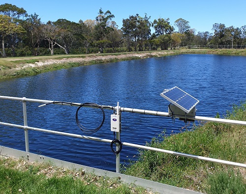
Senceive solutions have been deployed at the Elanora wastewater treatment plan.
Having successfully deployed Senceive solutions on a range of projects, including Gold Coast light rail, Sparkes Hill reservoir in Brisbane’s north, and the Elanora wastewater treatment plan on the Gold Coast, among others, Bennett and Bennett further expanded its monitoring services with the addition of the Omnidots vibration monitoring solutions.
On a high-rise tower in Brisbane’s CBD, both Senceive and Omnidots systems were used to check for movement and vibration during excavation work for the Albert Street Tunnel, part of the city’s Cross River Rail Project.
“We set up alerts as well as dashboard access for the building manager and the structural engineer on the high-rise building project, which they valued enormously because they could check the information themselves whenever they wanted to,” said Bennett and Bennett company Director, Chris Swane.
“I believe they also gave access to some tenants in the building who were particularly concerned about the construction work going on around them and the vibration it was causing to the building. When they had full visibility and could see that the vibration was kept below alert levels, it gave them peace of mind,” he added.
As with any new technology, the upskilling and on-boarding process was important to get right, according to Mr Swane. “The support and advisory capacity of the local Position Partners team in Brisbane has been excellent,” he said. “They provided a great deal of advice about the systems and helped us understand the different options and suitability, which changes over time as new technology becomes available. We also relied on them for training and getting the systems configured. I can’t fault Position Partners on the assistance and support we’ve been provided.”
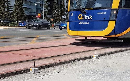
Senceive wireless monitoring was used on the Gold Coast light rail.
Prior to introducing the Senceive wireless monitoring platform, Bennett and Bennett used traditional surveying techniques to monitor movement in structures. “On a historic building, for example, we would have relied on angular measurement — reading multiple angles to a wall and setting up brackets at the top of the structure and at the bottom so that we could measure for any movement,” Mr Swane said.
“Those methods take a lot of time, you have to be on site to take those readings, whereas the Senceive and Omnidots systems operate around the clock once it’s setup,” he added. “Then of course there’s the cost to factor in; having a surveyor on site to take those measurements at the standard charge out rate makes it much more cost effective for our clients to have the wireless monitoring systems installed on their sites.”
Mr Swane said that in addition to the constant data feeds and cost savings from wireless monitoring technology, the ability to configure alerts for different parameters of movement or vibration is also well received by clients. “There’s definitely some education involved to explain what these alerts really mean and relate them back to the millimetres of movement they relate to,” he explained.
“But the good thing about these systems is that you can set different levels of alerts that perhaps go to different stakeholders. For example, a low-level alert might go to the consultant and the surveyor as a forewarning, but a more critical alert level might go to the client and perhaps the builder on site, so if they hear or see it trigger they know to stop work immediately.”
Another benefit Mr Swane cites is that monitoring technology delivers a greater level of traceability. “Clients can compare any potential movement from the start of the year to the end of the year, or with vibration they can analyse trends in activity over time,” he said.
Like many surveying businesses, Bennett and Bennett has adapted to embrace newer surveying instruments to offer clients a broader service offering. “The wearable scanner and monitoring systems are the latest additions to the company and are in line with some of the more high-tech emerging services we now offer. From 3D mapping and BIM applications, to conformance reporting, construction and monitoring, it all ties well together and enables us to provide holistic solutions for our clients,” Mr Swane explained.