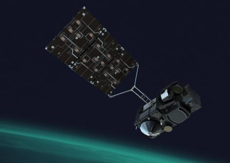
Preliminary Copernicus Sentinel-3C thermal infrared show Earth’s extremes, from Western Australia’s deserts to the ice sheets of Greenland.
The release of the images comes just two months after the satellite was launched, on 15 September.
They show the deserts of Western Australia and swirling seas off its north-western coastline, plus icy waters between Greenland and Iceland, and the heat of wildfires in Indonesia.
The thermal infrared images were captured by the satellite’s Sea and Land Surface Temperature Radiometer (SLSTR).
“SLSTR’s thermal channels read temperatures to within a few tenths of a degree,” said Milen Tahtadjiev, Copernicus Sentinel-3 Mission Manager at EUMETSAT.
“That precision is crucial for the forecast models that Europe’s weather services rely on, and for climate monitoring, including El Niño, marine heatwaves and long-term ocean warming.”
According to Tahtadjiev, the SLSTR data also will be able to show civil protection authorities where wildfires are burning and how fiercely, such as has happened in southern Europe in the middle of this year.
EUMETSAT’s fire products were the most downloaded Sentinel-3 products in its Data Store in 2025.
“With these incredible first images, we can be confident its measurements will keep supporting essential services for many years to come,” Tahtadjiev said.
The shortwave and thermal infrared images are joined by the first observations from the satellite’s two other main instruments, the Ocean and Land Colour Instrument and the Synthetic Aperture Radar Altimeter.
Western Australia in thermal infrared
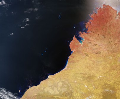
The images of north-western Australia were taken on 4 November 2026 at 09:34 local time.
In the shortwave infrared view, sunlight is reflected by the surface, showing red desert soil, darker vegetated ground in the Kimberley, blue sea and bright clouds.
Over the ocean this view shows little detail, apart from the coast and reefs. The shortwave infrared channels are very sensitive not only to the intense heat from fires, but also to burned areas left after fires are extinguished. That morning there were dozens of active fires scattered across the Kimberley.
In the thermal infrared view, the warm, shallow water of the North West Shelf glows almost white along the coast, while the open Indian Ocean is a few degrees colder. Swirls, filaments and ‘horsehead’ shapes show where colder water carried north by the West Australian Current mixes with the warmer South Equatorial Current. Shapes like these form where faster-moving water meets slower-moving water.
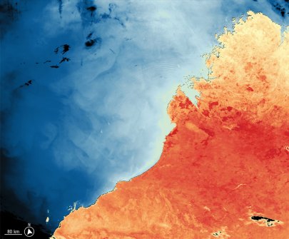
North-west of King Sound there are sets of parallel, arc-shaped ripples a few kilometres apart: these are internal gravity waves. The North West Shelf is one of the world’s hotspots for such waves, which form where strong tides push water over the edge of the shelf.
The images were taken during one of the strongest El Niño events on record. In northern Australia, fire danger is greatest late in the dry season, and in El Niño years the rains usually come later. The hot, humid pre-monsoon months known as “the build-up” then last longer.
Sentinel-3C is a third satellite in the Copernicus Sentinel-3 constellation. Once commissioning is complete, Sentinel-3C will take over from Sentinel-3A, while some Sentinel-3A observation capabilities will remain in operation.
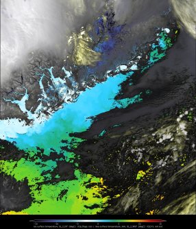
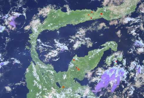
The first Sentinel-3C release also includes images of a swathe of sea and ice stretching from Greenland to Iceland, as well as a record of fires detected on Sulawesi in the Indonesian archipelago.
Related reading:
First images from Sentinel-3C’s land, ocean instruments
Launches add to Earth observation satellite fleets