A team from the Centre for Australian Research into Access (CARA) has used address-level intelligence to study access to care.
The team of researchers from CARA (part of Deakin University) led by Professors Neil Coffee and Vincent Versace, in partnership with Grampians Health, looked at the challenges faced by people living in rural and remote areas when accessing health services.
The large distances between homes and healthcare providers, combined with sparse populations and limited services, can conspire to inhibit the ability of residents to get the care they need, when they need it.
To study the problem, the researchers compiled multiple types of population and spatial data, particularly ‘address-level intelligence,’ and compared the result with that which would be obtained using traditional spatial administrative units.
Applying address-level intelligence for health outcomes
In a paper published in The Australian Journal of Rural Health, the team writes that “Current methods for understanding where healthcare need is greatest and guide investment are constrained by the application of existing spatial administrative units”.
“Administrative units tend to be larger in rural settings, masking locally important areas of heterogeneity — i.e., only the ‘average’ condition within a boundary is reported and therefore considered.”
Instead, the researchers say, “The widespread adoption of address-level intelligence describing the services available to a community based upon the time it takes to travel to services is offered as a scalable alternative to predefined spatial administrative units”.
And they say that this approach has already been successfully applied a number of times. “These include a system-level adoption at a large rural health service that spans approximately 300 km and services 250,000 residents, through to national analyses that have contributed to key policy areas in both health and education,” they write.
Integrating fine-resolution datasets
The key drawback to traditional methods of analysis, they say, is that commonly applied units of administrative areas are a blunt tool, often covering hundreds or thousands of square kilometres and thereby smoothing out small pockets of need within those areas.
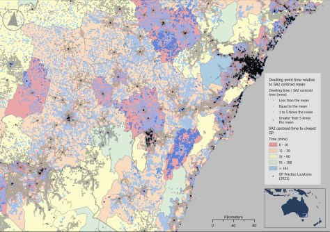
This is known as the Modifiable Areal Unit Problem (MAUP), where the selection of a spatial unit can affect the outcome. MAUP raises its head when, for instance, politicians in some jurisdictions gerrymander electoral boundaries for political gain.
The CARA team’s approach was to integrate fine-resolution datasets of both people and the services they need to access, along with transport data.
For the people side of the ledger, the team used satellite-derived building footprints, the Geocoded National Address File and the ABS Address Register, validated and refined to delete non-dwelling points.
For the healthcare facilities and education services side, they used state, territory and federal health services registries and an official list of schools.
These were combined with information on road distances, speed limits and historic speed data, turn and access restrictions and other factors. This enabled the team to calculate accurate routes and timings, rather than rely on unrealistic straight-line distances.
Once harmonised, the researchers performed network analyses, ‘connecting’ homes with the required service locations.
Identification of local patterns of health services access
In a report published in May, the CARA team outlines several concrete results of their work.
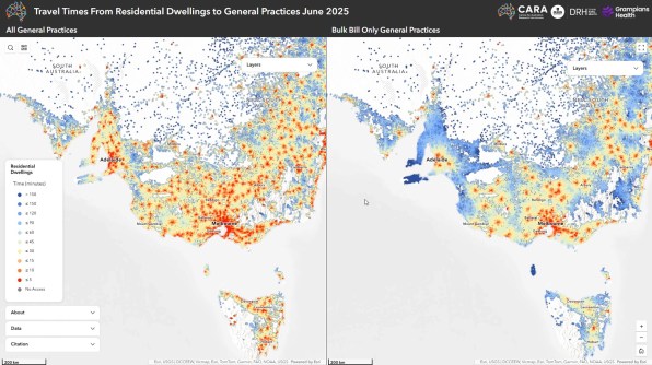
One of those results came from a collaboration with the Australian Bureau of Statistics. The researchers write that by “… combining CARA’s modelling with the ABS Address Register, CARA has been able to map where people live with greater accuracy, resulting in more reliable information about how far or the time it takes for people to travel to reach essential services”.
“The ABS Location Insights Branch has used these data as part of the Service Accessibility Explorer: An interactive national map and dashboard showing distance/ travel time to the closest key services including childcare, schools, hospitals and GPs.”
The CARA team says that a major motivation for its work has been to “mitigate the impact of the MAUP and the ecological fallacy in health research”.
“By operating at the dwelling level, CARA minimises these [MAUP] risks. Analysts can retain maximum spatial granularity, while still being able to aggregate results for reporting or comparison purposes”.
“This approach enables the identification of subtle local patterns, such as isolated communities with limited access, while avoiding the distortions introduced by large administrative units.”
“Moreover, CARA’s infrastructure is designed to be sustainable and interoperable, allowing the data to be exchanged and used by different systems and organisations,” the researchers add.
“Data can be updated regularly, new service types can be incorporated, and results can be shared with partner agencies while maintaining strict privacy controls.”
“The approach ensures that investments in health and education are guided by evidence in real-world access conditions rather than averages over large areas.”