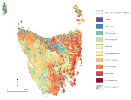
Tasmanian geospatial company Geoneon has released the latest Tasmania Wildfire Index, encompassing 450,356 building footprints across the state.
The Tasmania Wildfire Index 2026 aims to help communities, councils and other decision-makers explore relative modelled wildfire exposure for long-term preparedness and planning.
The Index can be used as a statewide screening resource that brings together landscape conditions and building-footprint context.
It covers all 29 Tasmanian local government areas and 769 suburbs, enabling users to compare both the number and the share of assessed building footprints in Wildfire Exposure Index (WEI) classes 7 to 10.
“These classes summarise relative modelled exposure around assessed building footprints,” said Dr Alex Bandini-Maeder, CTO and co-founder of Geoneon.
“They are not a prediction of when a fire will occur or a property-level risk rating.
“We want people to use the Index as screening evidence alongside local knowledge and official advice.”
Across Tasmania, 38,950 of 450,356 assessed building footprints — 8.6% — fall within WEI classes 7 to 10.
The Tasmania Wildfire Index 2026 was developed and funded by Geoneon, with support from Kingborough Council.
Making evidence easier to explore
The Index combines geospatial data representing vegetation and fuel, topography, and climate and dryness to model relative wildfire conditions across the landscape.
Those conditions are summarised around assessed building footprints as ordered WEI classes. The building-footprint counts are not direct counts of dwellings, addresses, properties or people.
“We built the Index to make statewide evidence easier to explore and use in preparedness conversations,” said Bandini-Maeder.
“The maps can help communities and decision-makers identify where more local investigation and planning may be valuable.”
Geoneon points out that the Index is not a live warning, a fire forecast, an evacuation guide, an expected-loss estimate, a complete measure of bushfire risk or a building-vulnerability assessment.
The company also says it should not be used for insurance, financial or regulatory decisions or in place of official emergency information.
More information about the Tasmania Wildfire Index 2026 is available online, plus there’s an interactive map and a downloadable report.
Related reading:
Geoneon wins three Australian Space Awards