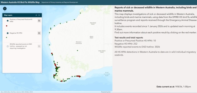
A new online dashboard reveals H5 bird flu detections across Western Australia.
As H5 bird flu begins its slow march across Australia, authorities are employing multiple technologies to keep track of its spread.
We reported recently on Victoria’s aerial campaign to spot and map potentially diseased birds, using a helicopter equipped with a high-resolution optical/infrared camera and carrying wildlife and mapping experts. Other states are doing similar.
Now, Western Australia has launched a publicly accessible online dashboard that maps the locations of positive H5 bird flu detections across the state, as well as the location of test results that have come back negative.
“This dashboard will give Western Australians an accessible picture of where detections have occurred and where surveillance and testing are taking place,” said Agriculture and Food Minister, Jackie Jarvis.
“The central bird flu website will help ensure poultry producers, veterinarians, wildlife carers and the community can access the latest information and practical advice in one place.”
Dealing with the spread of H5
As of Monday morning, Western Australia remained free of detected local transmission, but it must be only a matter of time before it occurs.
The state government is putting in place multiple measures to keep on top of the situation, including:
- regular engagement with the poultry industry, local governments, veterinarians and wildlife rehabilitators;
- enhanced surveillance and testing across the state;
- additional training for response personnel;
- the establishment of divisional commands in Perth, Esperance, Albany, Bunbury and Geraldton;
- the deployment of field teams to locations including Lancelin and Edwards Island to monitor wildlife populations;
Members of the public have been warned to not handle sick or dead wildlife, but to report it via the Emergency Animal Disease Hotline on 1800 675 888.
Do you know of other H5 bird flu dashboards or maps? Please let us know.