Researchers from São Paulo State University (UNESP), at its Tupã campus in Brazil, have developed and tested a new geospatial intelligence methodology for vegetation mapping that can contribute more quickly and accurately to land use management.
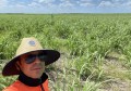
The tool was used to precisely delineate areas of Amazon rainforest, Cerrado vegetation (the Brazilian savannah-like biome), pastures and agricultural crops in a double-cropping system.
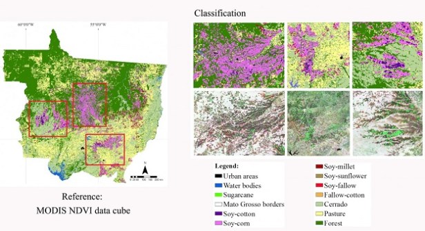
The researchers combined a data cube architecture (ready for analysis), disseminated in Brazil through the Brazil Data Cube project and led by the National Institute for Space Research (INPE), and the Geobia (Geographic Object-Based Image Analysis), and used time series’ of satellite images from NASA’s Modis (Moderate Resolution Imaging Spectroradiometer) sensor.
Via this approach, they were able to identify vegetation and double cropping — for example, soy and corn — over the course of a harvest in the state of Mato Grosso.
The results showed that the combination, coupled with machine learning (AI) algorithms, achieved 95% mapping accuracy.
Geobiology enables satellite images to be processed using segmentations that group similar pixels into geo-objects. In turn, this enables the study of their characteristics, such as shape, texture and reflectance. In many cases, this allows for a more realistic interpretation.
Data cubes, on the other hand, store information in dimensions — time and place — making it easier to aggregate and visualise information related to a specific location in a specific time period, such as crop areas in a harvest year.
Currently, mapping uses pixel image analysis in isolation, which ends up creating edge problems with blurring in some areas.
“Scientific work has highlighted spectral confusion in border zones between different land uses as an area for improvement. So we decided to segment the images and evaluate the geographical object as the minimum unit of analysis, rather than the pixel,” said Michel Eustáquio Dantas Chaves, professor at the Faculty of Science and Engineering of UNESP and corresponding author of the article.
“It’s as if the image were broken down and classified according to each piece. In this way, we were able to reduce recurring edge errors and accurately identify the targets, even with moderate spatial resolution.”
Chaves has been using data cube architecture for several years to develop tools that contribute to analyses focused on the advancement of the agricultural frontier, especially in the Cerrado.
According to Chaves, the methodology can be replicated to evaluate images from other Earth observation satellites, such as Landsat and Sentinel, which provide data for scientific studies, mapping and monitoring. Images from both are now being processed by the team coordinated by the professor.
Chaves says the methodology also makes it possible to analyse disturbances in forests and other types of natural vegetation.
“It’s quicker to detect deforestation than degradation. This method allowed us to detect these variations more quickly,” he said.
The article describing the vegetation mapping methodology has been published in the special issue Research Progress and Challenges of Agricultural Information Technology of the scientific journal AgriEngineering.
Read more about vegetation mapping: