

Victoria’s new four-in-one, streamlined LASSI platform is now live.
As we reported last month, the new LASSI platform will be used by surveyors, the construction industry and governments to plan land developments, prepare surveys, and update or add place names, survey marks and historical information.
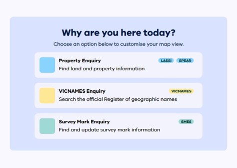
Users can now access four services through the single platform:
- Land and Survey Spatial Information (LASSI)
- Survey Marks Enquiry Service (SMES)
- VICNAMES register
- LASSI-SPEAR (Surveying and Planning through Electronic Applications and Referrals)
Although much of the functionality remains familiar, there is a new interface, new tools, an improved search system, and it can be used on desktop, tablet or mobile devices.
Being mobile friendly means, for instance, that registered SMES users can update survey marks or make new submissions in the field.
The platform is now cloud-based, which aims to improve stability, performance and security.
Tasks in the upgraded LASSI platform are said to be more consistent and predictable, coming with clearer guidance and fewer steps. A built-in Wiki provides extra guidance and troubleshooting options.


