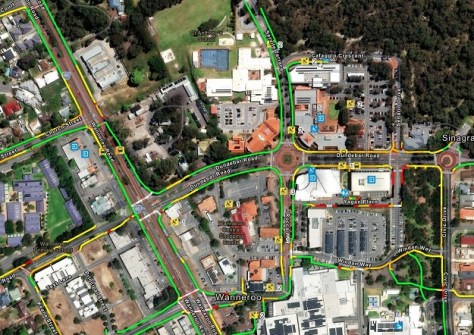
The City of Wanneroo’s first mobility map is set to improve access to the town centre for those with limited mobility.
Developed in partnership with accessibility specialists, Sydney based Briometrix, the mobility map connects Wanneroo to a growing national network of mobility mapped locations using innovative accessibility data.
The map will help residents and visitors choose paths that best suit their mobility needs, including people who use wheelchairs, mobility aids, prams or simply those who prefer flatter, smoother surfaces.
The City of Wanneroo is located in Perth’s northern suburbs.
To gather the data, trained wheelchair pilots travelled along 37 kilometres of footpaths carrying smart sensors that measure real world conditions from the perspective of a person with limited mobility.
Wanneroo Town Centre is the first area in the City to be published, and there are plans to map Clarkson, Yanchep and Girrawheen in the future.
More accessible communities
Mayor Linda Aitken said the new mobility map helped the community plan safer, easier routes.
“We’re excited to share the new mobility map for the Wanneroo town centre, a tool designed to help you move around your community with confidence,” she said.
“Using real data collected by trained wheelchair pilots, the map shows how challenging each footpath may be, so you can choose the route that feels right for you.
“Mobility mapping across our key activity centres highlights the City’s commitment to making the community more inclusive and accessible for everyone.”
The Mobility Map translates real accessibility data into an easy‑to‑read digital display, with each route rated by its required level of effort (colour-coded green, yellow, orange, red or black) based on factors such as:
- slope and crossfall
- surface quality and roughness
- uneven or bumpy areas
- ramps, inclines and crossings
- how physically demanding a route may feel
A mobility map for helping everyone
Former City of Wanneroo Disability Access and Inclusion Advisory Group Member Andrew Fairbairn was a wheelchair pilot for the project and said mapping the City’s town centres was a great idea.
“As a wheelchair user, I know how different features like gradients, surfaces and ramps can make a real difference for people with mobility challenges and can help them navigate public spaces with greater confidence and safety,” he said.
“But this map is not just for wheelchair users, the City of Wanneroo has a lot of older residents, people using walkers, as well as new parents with prams.
“A good, connected path network can help everyone — if people can see pathway access set out on a website, that can help with planning an outing and make journeys smoother.”
The Wanneroo Town Centre Mobility Map can be accessed using any smartphone, tablet or computer.