This article was written by Julia Reynolds* and originally published in the Aug/Sep 2016 Issue of Position magazine.
As consultants in the business of investigating underground voids and cavities, Austech Surveying & Mapping are sometimes asked to look at more unusual situations. One such investigation was determining the extent and size of some natural cave systems on the south-western coast of Victoria near Warrnambool.
These deep cavities were created long ago by the natural elements of wind and sea erosion and now are a maternal roost home for a colony of critically-endangered Southern Bent-wing Bats.
The Arthur Rylah Institute for Environmental Research (ARI) centre contracted Austech to investigate extent of the cavities into the land from the shoreline cliffs and how close the cave system came to the farmland surface above.
Initially the investigations had involved physical entry to the cave system, and once inside a survey of the internal extents was performed using standard techniques with a total station. While this produced adequate results for the floor and walls, the roofs of the caves were often inaccessible or impossible to see due to overhangs and various obstructions. Hence, it was difficult to be confident about the extent of the cave system and the thickness of the cave roof. The physical access was difficult as it involved rappelling down cliff faces, and carrying gear across rocks ahead of incoming tides. Clearly, a better way to collect the data was needed!
To get stories like this delivered to your mailbox every week, subscribe to our weekly newsletter.Survey consultants, BEAM Surveys, decided that a robotic remote controlled cavity scanning system would be ideal for this scenario. The robotic scanner could be fed down to the cave systems via a number of holes that had formed on the paddock surface and went down though to the voids. BEAM Surveys therefore contacted Austech who are experts in the deployment of Renishaw’s Cavity Auto-scanning Laser System (C-ALS), a borehole deployable laser scanner specifically designed for concealed cavity and void scanning.
The deployment
The scanning needed to be done at night in order to minimise disturbance to the bats where many of the females were due to give birth to their young in the cave system’s roosting zones.

Surveyors rapel into the cave entrance.
Due to the unknown amount of ground cover above the cave ceiling, field staff were also required to be harnessed and anchored with safety lines before approaching the cave openings
On arriving at the site at dusk, the gear was prepared for deployment. The lowering of the remotely controlled scanner could not be done until the team were confident that the majority of the bats had left their roosting spots for the night. While the scanning would not harm the bats in any way, it was preferred to keep any disturbance to an absolute minimum.
Once nightfall had arrived and the bats had flown out through the access points on the cliffs, it was time to begin.
The technique adopted was to insert the scanner down some small access holes. Initially it was lowered into cavities just a few metres to get detailed scans of the ceiling at those points. Then, the scan unit was lowered further down into the cave to get more details in the mid sections. The scans from the different depths were then combined to create a more detailed point cloud of the upper reaches of the cavity systems.
This was repeated for several of the ground hole access points in the paddock. Where there was any possibility of ground collapse, safety harnesses were used as a precaution.
Outcome

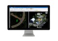
The resulting 3D model of the cave complex (click to view).
Once the various scans had been completed and merged, it was possible to produce a georeferenced point cloud of the cave system. This was in turn merged with the previous work to create a full 3d model of the zones including measurements of ‘ceiling thicknesses’ at various points. The results were then used by the Arthur Rylah Institute for Environmental Research to document concerns on the stability of the cave systems as well as the integrity of the paddock surface.
According to Dr Lindy Lumsden from the Arthur Rylah Institute for Environmental Research, “the use of the remote controlled scanning instrument allowed them to gain valuable data and insight into the extent and condition of the voids via access holes which was much easier and safer than previous methods.”
*Julia Reynolds is the general manager of Austech Surveying & Mapping Pty Ltd. Austech services a wide range of industry sectors including mining, quarry and construction throughout Australia, New Zealand and South East Asia.